IMAGES TAKEN NEAR TO
Vale View Close, PENARTH, CF64 2QB
Introduction
This page details the photographs taken nearby to Vale View Close, CF64 2QB by members of the Geograph project.
The Geograph project started in 2005 with the aim of publishing, organising and preserving representative images for every square kilometre of Great Britain, Ireland and the Isle of Man.

There are currently over 7.5m images from over14,400 individuals and you can help contribute to the project by visiting https://www.geograph.org.uk
Image Map
Images are licensed for reuse under creativecommons.org/licenses/by-sa/2.0
Notes
- Clicking on the map will re-center to the selected point.
- The higher the marker number, the further away the image location is from the centre of the postcode.
Image Listing (36 Images Found)
Images are licensed for reuse under creativecommons.org/licenses/by-sa/2.0
Image
Details
Distance
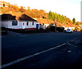
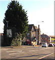
2
The A4055 Barry Road heads away from Llandough
Viewed from the edge of The Merrie Harrier. http://www.geograph.org.uk/photo/3325462
Image: © Jaggery
Taken: 9 Dec 2012
0.04 miles
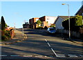
3
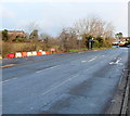
Penlan Road, Llandough
Penlan Road climbs away from the Barry Road junction.
Image: © Jaggery
Taken: 9 Dec 2012
0.05 miles
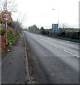
4
Andrew Road bungalows, Penarth
This part of Andrew Road is between the A4055 Barry Road to the north and the Vale of Glamorgan Line railway to the south.
Image: © Jaggery
Taken: 25 Nov 2016
0.06 miles
5
Directions sign in a Penlan Road hedge, Llandough
Facing the B4267 on the approach to the A4055 junction, the sign shows the way to Barry, Sully and Penarth.
Image: © Jaggery
Taken: 25 Nov 2016
0.06 miles
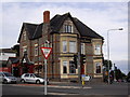
6

The Merrie Harrier
The Merrie Harrier, Llandough.
Image: © Alan Hughes
Taken: 4 Apr 2016
0.06 miles
7
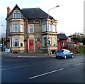
South side of The Merrie Harrier, Llandough
Pub on the corner of Barry Road and Penlan Road, near the Penarth boundary sign.
Image: © Jaggery
Taken: 9 Dec 2012
0.07 miles
8
Dochdwy Road, Llandough
Dochdwy Road ascends away from the east side of the B4267 Penlan Road.
Image: © Jaggery
Taken: 25 Nov 2016
0.08 miles
9
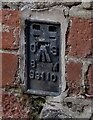
Ordnance Survey Flush Bracket (S9110)
This OS Flush Bracket can be found on the Merry Harrier PH. It marks a point 38.323m above mean sea level.
Image: © Adrian Dust
Taken: 17 Sep 2021
0.08 miles
10

West side of The Merrie Harrier, Llandough
Pub on the corner of Barry Road and Penlan Road,
near both the Penarth boundary sign and the Llandough boundary sign. http://www.geograph.org.uk/photo/3325493
Image: © Jaggery
Taken: 9 Dec 2012
0.08 miles