IMAGES TAKEN NEAR TO
Canon Walk, PENARTH, CF64 2NE
Introduction
This page details the photographs taken nearby to Canon Walk, CF64 2NE by members of the Geograph project.
The Geograph project started in 2005 with the aim of publishing, organising and preserving representative images for every square kilometre of Great Britain, Ireland and the Isle of Man.

There are currently over 7.5m images from over14,400 individuals and you can help contribute to the project by visiting https://www.geograph.org.uk
Image Map
Images are licensed for reuse under creativecommons.org/licenses/by-sa/2.0
Notes
- Clicking on the map will re-center to the selected point.
- The higher the marker number, the further away the image location is from the centre of the postcode.
Image Listing (53 Images Found)
Images are licensed for reuse under creativecommons.org/licenses/by-sa/2.0
Image
Details
Distance
1

Former Llandough Scout and Guide Association Hall, Lewis Road
Image: © Ben Meyrick
Taken: 12 Oct 2022
0.02 miles
2
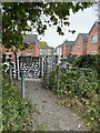
Gateway from King George V Playing Field to Canon Wall
Image: © Ben Meyrick
Taken: 12 Oct 2022
0.03 miles
3
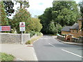
Llandough Hill
Llandough Hill descends towards Penarth Road. Ahead, there is no footway for 200 yards. On the left is St Dochdwy's Church.http://www.geograph.org.uk/photo/2043686
Image: © Jaggery
Taken: 5 Aug 2010
0.03 miles
4

GWR bench, Llandough
A dark brown bench, with white letters GWR underneath the seat, is located at the edge of a grassy area between the B4267 and St Dochdwy's church. http://www.geograph.org.uk/photo/2043686
How a bench from the GWR (Great Western Railway) came to be located here is not known by this contributor. There was once a small railway station (Llandough Platform) in the village, but that closed in 1918, and was on the Taff Vale Railway, which did not become part of the GWR until 1922.
http://www.geograph.org.uk/photo/1688666 to another ex-GWR bench in a railway setting.
Image: © Jaggery
Taken: 5 Aug 2010
0.03 miles
5
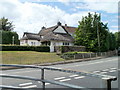
The last remaining thatched cottage in Llandough
Located on the west side of the B4267, opposite Llandough Hill.
Image: © Jaggery
Taken: 5 Aug 2010
0.03 miles
6
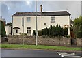
The Policeman's House and Old Post Office, Llandough
Number 18 and 20 Penlan Road were built between 1840 and 1874 in stonework with slate roofs.
Number 20 was the village's police station until around 1954. Its garage incorporated the Air Raid Precautions post during World War II.
Number 18 was the original Post Office for Llandough.
Image: © Ben Meyrick
Taken: 7 Oct 2022
0.05 miles
10
Church View Close, Llandough
Viewed from Leckwith Road.
Image: © Jaggery
Taken: 5 Aug 2010
0.06 miles