
IMAGES TAKEN NEAR TO
Woodland Hall, Woodland Place, PENARTH, CF64 2EA
Introduction
This page details the photographs taken nearby to Woodland Hall, Woodland Place, CF64 2EA by members of the Geograph project.
The Geograph project started in 2005 with the aim of publishing, organising and preserving representative images for every square kilometre of Great Britain, Ireland and the Isle of Man.

There are currently over 7.5m images from over14,400 individuals and you can help contribute to the project by visiting https://www.geograph.org.uk
Image Map
Images are licensed for reuse under creativecommons.org/licenses/by-sa/2.0
Notes
- Clicking on the map will re-center to the selected point.
- The higher the marker number, the further away the image location is from the centre of the postcode.
Image Listing (274 Images Found)
Images are licensed for reuse under creativecommons.org/licenses/by-sa/2.0
Image
Details
Distance
1
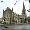
Trinity Methodist Church, Penarth
Trinity Methodist Church, Stanwell Road, Penarth.
Image: © Alan Hughes
Taken: 13 Jan 2016
0.04 miles
2
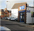
O'Neils Car Sales, Cornerswell Road, Penarth
The premises at 3 Cornerswell Road were formerly occupied by Motortrade Direct Ltd of Penarth.
In the background is Wood Street post office. http://www.geograph.org.uk/photo/1972519
Image: © Jaggery
Taken: 5 Feb 2010
0.07 miles
3
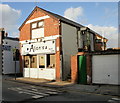
Alan's Unisex Salon, Penarth
Hairdressers on Cornerswell Road, next door to O'Neils Car Sales. http://www.geograph.org.uk/photo/1972534
Image: © Jaggery
Taken: 5 Feb 2010
0.07 miles
4
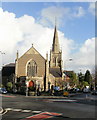
Trinity Methodist Church, Penarth
Located on the corner of Woodland Place and Stanwell Road. Construction work on the church began in 1899. It opened for worship in 1901, replacing a prefabricated, corrugated iron ‘Tin Church’, erected here in 1887.
Image: © Jaggery
Taken: 5 Feb 2010
0.07 miles
5
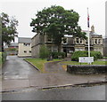
West House, Penarth
Penarth Town Council offices set back from the north side of Stanwell Road.
Image: © Jaggery
Taken: 28 Jul 2016
0.10 miles
6
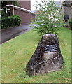
Town twinning plaque, Penarth
Located here http://www.geograph.org.uk/photo/5094705 in front of West House. The plaque was unveiled by Monsieur A.Kervella Mayor of Saint-Pol-de-Léon (Brittany, France) on July 7th 1990 to mark the twentieth anniversary of the twinning of the towns.
Image: © Jaggery
Taken: 28 Jul 2016
0.10 miles
7

Information board outside Stanwell Road Baptist Church, Penarth
Located here. http://www.geograph.org.uk/photo/5052858
Image: © Jaggery
Taken: 28 Jul 2016
0.10 miles
8
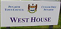
Penarth Civic Insignia and Crest
Depicted on the name sign for West House, Penarth Town Council's offices. http://www.geograph.org.uk/photo/5094705
The Welsh motto Cynghori er Llesiant means Counsel for Benefit (or Gain).
The town crest was drawn by the town's architect in 1875 from a detailed brief prepared by the Town Board. It shows a bear's head above a shield supported by two standing bears. The shield depicts contains a Welsh Red Dragon to denote that the town is in Wales and a sailing vessel symbolising Penarth's long association with sea commerce.
The reference to bears is from a literal translation of Penarth. In Welsh, arth is bear and pen is head. Although that used to be the accepted derivation of the town's name, some modern scholars have suggested that the name is a shortened form of Pen-y-garth, where garth means cliff, hence head of the cliff or cliff top(s).
Image: © Jaggery
Taken: 28 Jul 2016
0.11 miles
9
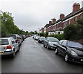
On-street parking, Dingle Road, Penarth
The view southeast from the corner of West Terrace. The cars on the left are parked alongside the perimeter fence of the Vale of Glamorgan Line (Penarth Branch) railway between Dingle Road station and the branch's terminus at Penarth station.
Image: © Jaggery
Taken: 28 Jul 2016
0.11 miles
10
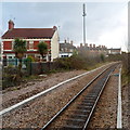
A view SE from the edge of Dingle Road railway station, Penarth
Viewed from the edge of the single platform, about 120 metres from the station entrance, http://www.geograph.org.uk/photo/3253833
looking in the direction of the line's terminus at Penarth station.
The house on the left is in Windsor Place. The row of houses parallel with the railway
in the distance is Railway Terrace.
Image: © Jaggery
Taken: 9 Dec 2012
0.11 miles