IMAGES TAKEN NEAR TO
Victoria Bridge, PENARTH, CF64 2AN
Introduction
This page details the photographs taken nearby to Victoria Bridge, CF64 2AN by members of the Geograph project.
The Geograph project started in 2005 with the aim of publishing, organising and preserving representative images for every square kilometre of Great Britain, Ireland and the Isle of Man.

There are currently over 7.5m images from over14,400 individuals and you can help contribute to the project by visiting https://www.geograph.org.uk
Image Map
Images are licensed for reuse under creativecommons.org/licenses/by-sa/2.0
Notes
- Clicking on the map will re-center to the selected point.
- The higher the marker number, the further away the image location is from the centre of the postcode.
Image Listing (299 Images Found)
Images are licensed for reuse under creativecommons.org/licenses/by-sa/2.0
Image
Details
Distance
1
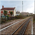
A view SE from the edge of Dingle Road railway station, Penarth
Viewed from the edge of the single platform, about 120 metres from the station entrance, http://www.geograph.org.uk/photo/3253833
looking in the direction of the line's terminus at Penarth station.
The house on the left is in Windsor Place. The row of houses parallel with the railway
in the distance is Railway Terrace.
Image: © Jaggery
Taken: 9 Dec 2012
0.03 miles
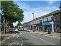
2
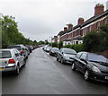
On-street parking, Dingle Road, Penarth
The view southeast from the corner of West Terrace. The cars on the left are parked alongside the perimeter fence of the Vale of Glamorgan Line (Penarth Branch) railway between Dingle Road station and the branch's terminus at Penarth station.
Image: © Jaggery
Taken: 28 Jul 2016
0.04 miles
3
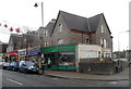
Pearn's Pharmacy, Penarth
On the corner of Windsor Road and Arcot Street. Fferyllfa is Welsh for pharmacy.
Image: © Jaggery
Taken: 9 Dec 2012
0.05 miles
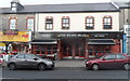
4
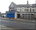
RAFA Club, Penarth
The Royal Air Forces Association Penarth Branch & Club is at 40-42 Windsor Road.
Image: © Jaggery
Taken: 9 Dec 2012
0.06 miles
6
The Bears Head, Penarth
The Wetherspoon pub at 37-39 Windsor Road takes its name from a literal translation of Penarth.
In Welsh, arth is bear and pen is head. Although that used to be the accepted derivation of the town's name, some modern scholars have suggested that the name is a shortened form of Pen-y-garth,
where garth means cliff, hence head of the cliff or cliff top(s).
Image: © Jaggery
Taken: 9 Dec 2012
0.07 miles
7
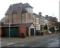
Bradenham Place houses, Penarth
Viewed looking towards Hickman Road.
Image: © Jaggery
Taken: 9 Dec 2012
0.07 miles
8
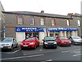
Wasons DIY Penarth
This is the Arcot Street side of the shop at 43-45 Windsor Road.
Image: © Jaggery
Taken: 9 Dec 2012
0.07 miles
9
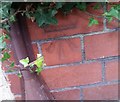
Ordnance Survey Cut Mark
This OS cut mark can be found on the wall of No57 Windsor Road. It marks a point 45.284m above mean sea level.
Image: © Adrian Dust
Taken: 25 Sep 2017
0.08 miles
10
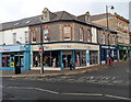
Tenovus, Penarth
Charity shop on the corner of Windsor Road and Glebe Street. Tenovus was founded in 1943 by ten businessmen, the original ten-of-us. Initially, the charity funded a wide range of projects, but since the 1960s, its focus has been on cancer.
Image: © Jaggery
Taken: 9 Dec 2012
0.08 miles