IMAGES TAKEN NEAR TO
Pearse Close, PENARTH, CF64 1TH
Introduction
This page details the photographs taken nearby to Pearse Close, CF64 1TH by members of the Geograph project.
The Geograph project started in 2005 with the aim of publishing, organising and preserving representative images for every square kilometre of Great Britain, Ireland and the Isle of Man.

There are currently over 7.5m images from over14,400 individuals and you can help contribute to the project by visiting https://www.geograph.org.uk
Image Map
Images are licensed for reuse under creativecommons.org/licenses/by-sa/2.0
Notes
- Clicking on the map will re-center to the selected point.
- The higher the marker number, the further away the image location is from the centre of the postcode.
Image Listing (102 Images Found)
Images are licensed for reuse under creativecommons.org/licenses/by-sa/2.0
Image
Details
Distance
1
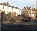
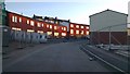
Hill Terrace, Penarth
A terrace of about 12 colourful houses on Windsor Road
Image: © Eirian Evans
Taken: 4 May 2019
0.08 miles
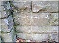
2
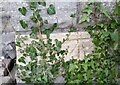
Ordnance Survey Cut Mark
This OS cut mark can be found on the west angle of the Holy Nativity Church. It marks a point 34.574m above mean sea level.
Image: © Adrian Dust
Taken: 17 Sep 2021
0.10 miles
3
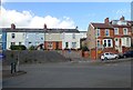
Hill Terrace and Plassey Street, Penarth
Hill Terrace on the left; Plassey Street on the right. Viewed from the edge of the Windsor Road roundabout.
Image: © Jaggery
Taken: 24 Nov 2010
0.10 miles
4
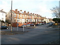
Plassey Street, Penarth
A long row of houses on Plassey Street climbs away from Windsor Road.
Image: © Jaggery
Taken: 24 Nov 2010
0.10 miles
5
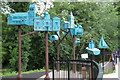
Sculpture at entrance to Dingle Park
The sculpture depicts many well-known buildings in Penarth.
Image: © Gareth James
Taken: 5 Aug 2020
0.11 miles
6
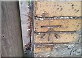
Ordnance Survey Cut Mark
This OS cut mark can be found on the wall of No123 Plassey Street. It marks a point 42.666m above mean sea level.
Image: © Adrian Dust
Taken: 25 Sep 2017
0.12 miles
7
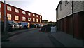
Rear of St Joseph's Mews, Penarth Heights
New houses at St Joseph's Mews, Penarth Heights
Image: © Christopher R Ware
Taken: 23 May 2012
0.12 miles
8
Ordnance Survey Cut Mark
This OS cut mark can be found on the SW buttress of the railway bridge on Windsor Road. It marks a point 20.879m above mean sea level.
Image: © Adrian Dust
Taken: 17 Sep 2021
0.14 miles
9
St Joseph's Mews, Penarth Heights
The rear of the new development at Penarth Heights, St Joseph's Mews
Image: © Christopher R Ware
Taken: 23 May 2012
0.14 miles
10
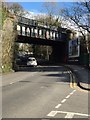
Railway Bridge
Cardiff to Penarth railway bridge at Cogan.
Image: © Alan Hughes
Taken: 4 Apr 2016
0.14 miles