IMAGES TAKEN NEAR TO
Trem Elai, PENARTH, CF64 1TF
Introduction
This page details the photographs taken nearby to Trem Elai, CF64 1TF by members of the Geograph project.
The Geograph project started in 2005 with the aim of publishing, organising and preserving representative images for every square kilometre of Great Britain, Ireland and the Isle of Man.

There are currently over 7.5m images from over14,400 individuals and you can help contribute to the project by visiting https://www.geograph.org.uk
Image Map
Images are licensed for reuse under creativecommons.org/licenses/by-sa/2.0
Notes
- Clicking on the map will re-center to the selected point.
- The higher the marker number, the further away the image location is from the centre of the postcode.
Image Listing (70 Images Found)
Images are licensed for reuse under creativecommons.org/licenses/by-sa/2.0
Image
Details
Distance
1
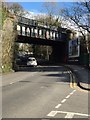
Railway Bridge
Cardiff to Penarth railway bridge at Cogan.
Image: © Alan Hughes
Taken: 4 Apr 2016
0.09 miles
2
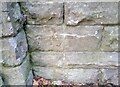
Ordnance Survey Cut Mark
This OS cut mark can be found on the SW buttress of the railway bridge on Windsor Road. It marks a point 20.879m above mean sea level.
Image: © Adrian Dust
Taken: 17 Sep 2021
0.10 miles
3
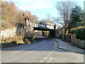
Railway bridge, Windsor Road, Penarth
Viewed from the corner of Bridge Street.
The bridge, with a rather faded advert for Brains Dark (ale),carries a single-track railway line above Windsor Road. The railway route is from Cogan Junction to Dingle Road and Penarth stations.
Image: © Jaggery
Taken: 24 Nov 2010
0.11 miles
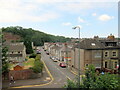
4
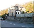
Lone house, Windsor Road, Penarth
In contrast with the long rows of houses on the other side of the road, the NE side of Windsor Road in this area, adjacent to a railway line, has only this one house along a 250 metre section. The strip of land without houses is used for allotments.
Image: © Jaggery
Taken: 24 Nov 2010
0.11 miles
5
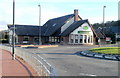
The Oystercatcher, Penarth
A Hungry Horse pub and restaurant, located at the corner of Terra Nova Way and Marconi Avenue.
Image: © Jaggery
Taken: 24 Nov 2010
0.12 miles
6
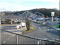
Tesco superstore, Penarth
Tesco petrol station, car park and superstore, located on Terra Nova Way. Opening hours in late November 2010 were 6am to midnight every day, except Sundays (10am to 4pm).
Image: © Jaggery
Taken: 24 Nov 2010
0.12 miles
8
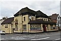
The Station - former public house
The splendid former public house was built at the turn of the 20th century. Having served the local community for over 100 years it is now threatened with demolition and to be replaced with a concrete block of flats. Such a shame - it could so easily be repurposed to accommodation.
Image: © Colin Cheesman
Taken: 11 Nov 2021
0.13 miles
9
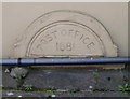
Cogan : Post Office 1881 inscription
POST OFFICE 1881 is inscribed on this building http://www.geograph.org.uk/photo/2185227 in Cogan.
Image: © Jaggery
Taken: 24 Nov 2010
0.13 miles
10
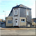
Cogan's first post office
This private residence on the corner of Pill Street and Windsor Road, opposite The Station pub http://www.geograph.org.uk/photo/2184877 was probably the first post office in Cogan. A semicircular inscription http://www.geograph.org.uk/photo/2185231 near ground level on the left shows Post Office 1881.
A few tens of metres away, along Pill Street, the successor Cogan post office closed down in April 2008.
Image: © Jaggery
Taken: 24 Nov 2010
0.13 miles