IMAGES TAKEN NEAR TO
Bradford Place, PENARTH, CF64 1LA
Introduction
This page details the photographs taken nearby to Bradford Place, CF64 1LA by members of the Geograph project.
The Geograph project started in 2005 with the aim of publishing, organising and preserving representative images for every square kilometre of Great Britain, Ireland and the Isle of Man.

There are currently over 7.5m images from over14,400 individuals and you can help contribute to the project by visiting https://www.geograph.org.uk
Image Map
Images are licensed for reuse under creativecommons.org/licenses/by-sa/2.0
Notes
- Clicking on the map will re-center to the selected point.
- The higher the marker number, the further away the image location is from the centre of the postcode.
Image Listing (156 Images Found)
Images are licensed for reuse under creativecommons.org/licenses/by-sa/2.0
Image
Details
Distance
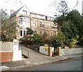
1
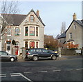
Orchard Day Nursery, Penarth
Privately-owned day nursery with places for 36 children, aged up to 7. Located in a semi-detached house (right side) at 46 Clive Place, facing Kymin Road.
Image: © Jaggery
Taken: 24 Nov 2010
0.04 miles
2
Scaffolding, Clive Place, Penarth
External work is being undertaken on a house on the north side of Clive Place. Viewed from the corner of Clive Crescent.
Image: © Jaggery
Taken: 24 Nov 2010
0.04 miles
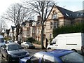
3
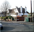
House on the corner of Clive Place and Jubilee Lane, Penarth
A house with a pair of prominent chimney stacks occupies the corner. An online Ordnance Survey map names the lane as Church Lane Avenue, but the name sign on the corner of Clive Place clearly shows Jubilee Lane.
Image: © Jaggery
Taken: 24 Nov 2010
0.04 miles
5
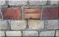
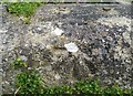
Ordnance Survey Cut Mark
This damaged OS cut mark can be found on the wall of No10 Church Road. It marks a point 53.873m above mean sea level.
Image: © Adrian Dust
Taken: 25 Sep 2017
0.07 miles
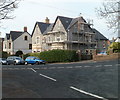
6
Cliffhaven, Penarth
Privately-owned retirement home for 19 residents, at 10 Clive Crescent.
Image: © Jaggery
Taken: 24 Nov 2010
0.07 miles
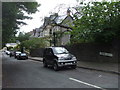
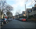
8
Church Road, Penarth
Church Road appears to be a popular location for on-street parking in Penarth.
Image: © Jaggery
Taken: 24 Nov 2010
0.07 miles
9
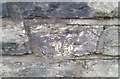
Ordnance Survey Cut Mark
This OS cut mark can be found on the wall of Kymin Cottage. It marks a point 41.663m above mean sea level.
Image: © Adrian Dust
Taken: 25 Sep 2017
0.08 miles
10
Ordnance Survey Cut Mark
This OS cut mark can be found on the wall NE side of Beach Road. It marks a point 41.005m above mean sea level.
Image: © Adrian Dust
Taken: 25 Sep 2017
0.10 miles