IMAGES TAKEN NEAR TO
Queens Road, PENARTH, CF64 1DL
Introduction
This page details the photographs taken nearby to Queens Road, CF64 1DL by members of the Geograph project.
The Geograph project started in 2005 with the aim of publishing, organising and preserving representative images for every square kilometre of Great Britain, Ireland and the Isle of Man.

There are currently over 7.5m images from over14,400 individuals and you can help contribute to the project by visiting https://www.geograph.org.uk
Image Map
Images are licensed for reuse under creativecommons.org/licenses/by-sa/2.0
Notes
- Clicking on the map will re-center to the selected point.
- The higher the marker number, the further away the image location is from the centre of the postcode.
Image Listing (186 Images Found)
Images are licensed for reuse under creativecommons.org/licenses/by-sa/2.0
Image
Details
Distance
1
Ordnance Survey Cut Mark
This OS cut mark can be found on No7 Stanwell Crescent. It marks a point 51.978m above mean sea level.
Image: © Adrian Dust
Taken: 25 Sep 2017
0.04 miles
2
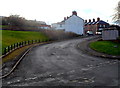
Stanwell Crescent, Penarth
Stanwell Crescent climbs away from the junction of John Street, Queens Road and Maugham Terrace.
Image: © Jaggery
Taken: 9 Dec 2012
0.04 miles
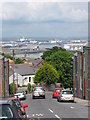
3

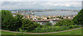
Stanwell Crescent, not to mention the hill, Penarth
Cardiff Bay can be seen in the background.
Image: © Ruth Sharville
Taken: 20 Sep 2021
0.04 miles
4
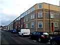
Row of 3-storey houses in Paget Road, Penarth
Viewed looking east from the edge of these http://www.geograph.org.uk/photo/3737460 steps.
Image: © Jaggery
Taken: 9 Dec 2012
0.05 miles
5
Stanwell Crescent, Penarth
Looking towards the Port of Cardiff.
Image: © Gareth James
Taken: 9 Jun 2010
0.06 miles
6

Maugham Terrace, Penarth
Houses on the west side of Maugham Terrace, viewed across John Street.
Image: © Jaggery
Taken: 9 Dec 2012
0.06 miles
7

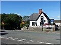
Corner of Maugham Terrace and John Street, Penarth
Curiously, there are four doors in this corner, each with a door handle. The ground floor door leads to a tiny fenced area, with no access to the street apart from climbing over the fence. Semi-transparent plastic panels are bolted onto the wall in front of the three upper floor doors. Are balconies to be installed?
Image: © Jaggery
Taken: 9 Dec 2012
0.06 miles
8

View of Penarth
From across Cardiff Bay
Image: © Darrin Antrobus
Taken: 24 Jan 2013
0.06 miles
9
View of Cardiff Bay from Paget Road, Penarth
Image: © Gareth James
Taken: 9 Jun 2010
0.06 miles
10
Road junction in Penarth
The view point is from Maughan Terrace, with Paget Place and the link road to Paget Road can also seen, along with a walkers' signpost.
Image: © Ruth Sharville
Taken: 20 Sep 2021
0.06 miles