IMAGES TAKEN NEAR TO
Kymin Road, PENARTH, CF64 1AR
Introduction
This page details the photographs taken nearby to Kymin Road, CF64 1AR by members of the Geograph project.
The Geograph project started in 2005 with the aim of publishing, organising and preserving representative images for every square kilometre of Great Britain, Ireland and the Isle of Man.

There are currently over 7.5m images from over14,400 individuals and you can help contribute to the project by visiting https://www.geograph.org.uk
Image Map
Images are licensed for reuse under creativecommons.org/licenses/by-sa/2.0
Notes
- Clicking on the map will re-center to the selected point.
- The higher the marker number, the further away the image location is from the centre of the postcode.
Image Listing (133 Images Found)
Images are licensed for reuse under creativecommons.org/licenses/by-sa/2.0
Image
Details
Distance
1
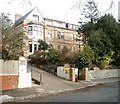
Cliffhaven, Penarth
Privately-owned retirement home for 19 residents, at 10 Clive Crescent.
Image: © Jaggery
Taken: 24 Nov 2010
0.02 miles
2
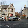
Orchard Day Nursery, Penarth
Privately-owned day nursery with places for 36 children, aged up to 7. Located in a semi-detached house (right side) at 46 Clive Place, facing Kymin Road.
Image: © Jaggery
Taken: 24 Nov 2010
0.05 miles
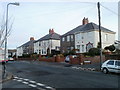
3
Scaffolding, Clive Place, Penarth
External work is being undertaken on a house on the north side of Clive Place. Viewed from the corner of Clive Crescent.
Image: © Jaggery
Taken: 24 Nov 2010
0.05 miles
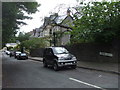
4
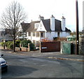
House on the corner of Clive Place and Jubilee Lane, Penarth
A house with a pair of prominent chimney stacks occupies the corner. An online Ordnance Survey map names the lane as Church Lane Avenue, but the name sign on the corner of Clive Place clearly shows Jubilee Lane.
Image: © Jaggery
Taken: 24 Nov 2010
0.05 miles
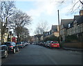
6
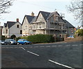
Church Place South, Penarth
A row of houses on the SW side of Church Place South, viewed across Clive Place.
Image: © Jaggery
Taken: 24 Nov 2010
0.08 miles
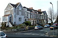
7
Jenkinsvill, Penarth
These six semi-detached houses on Clive Place are known as Jenkinsvill.
This spelling is confirmed on maps and on name signs at the location, though most estate agents' websites show Jenkinsville. The turning for Penarth Head Lane is on the right.
Image: © Jaggery
Taken: 24 Nov 2010
0.08 miles
9
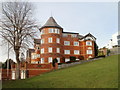
Osborne, Clive Crescent, Penarth
A side view of a modern apartment building named Osborne located at 7 Clive Crescent, about 50 metres west of the Bristol Channel shoreline.
Image: © Jaggery
Taken: 24 Nov 2010
0.08 miles
10
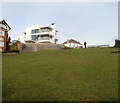
Narrow open space next to coastal slopes, Penarth
The view north along a 90 metres by 20 metres open space to the east of Clive Crescent (just beyond the lower left corner) and Penarth Head Lane (at the top left). Coastal slopes at Penarth Head begin just beyond the right edge of the view.
Image: © Jaggery
Taken: 24 Nov 2010
0.08 miles