IMAGES TAKEN NEAR TO
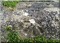
Beach Lane, PENARTH, CF64 1AN
Introduction
This page details the photographs taken nearby to Beach Lane, CF64 1AN by members of the Geograph project.
The Geograph project started in 2005 with the aim of publishing, organising and preserving representative images for every square kilometre of Great Britain, Ireland and the Isle of Man.

There are currently over 7.5m images from over14,400 individuals and you can help contribute to the project by visiting https://www.geograph.org.uk
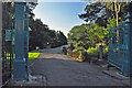
Image Map
Images are licensed for reuse under creativecommons.org/licenses/by-sa/2.0
Notes
- Clicking on the map will re-center to the selected point.
- The higher the marker number, the further away the image location is from the centre of the postcode.
Image Listing (249 Images Found)
Images are licensed for reuse under creativecommons.org/licenses/by-sa/2.0
Image
Details
Distance
1
Ordnance Survey Cut Mark
This OS cut mark can be found on the wall of Kymin Cottage. It marks a point 41.663m above mean sea level.
Image: © Adrian Dust
Taken: 25 Sep 2017
0.03 miles
2
Ordnance Survey Cut Mark
This OS cut mark can be found on the wall NE side of Beach Road. It marks a point 31.007m above mean sea level.
Image: © Adrian Dust
Taken: 25 Sep 2017
0.04 miles
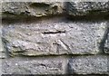
3

Ordnance Survey Cut Mark
This OS cut mark can be found on the wall NE side of Beach Road. It marks a point 41.005m above mean sea level.
Image: © Adrian Dust
Taken: 25 Sep 2017
0.05 miles
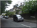
4
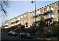
Albany Court flats, Penarth
Flats at the top end of Beach Road, facing Rectory Road.
Image: © Jaggery
Taken: 24 Nov 2010
0.06 miles
5
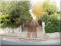
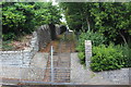
Steps up to a footpath from Beach Road, Penarth
On the west side of The Kymin, http://www.geograph.org.uk/photo/2173695 steps lead away from Beach Road up to a footpath which ascends to the corner of Beach Lane and Kymin Terrace.
Image: © Jaggery
Taken: 24 Nov 2010
0.06 miles
6
Entrance to Alexandra Park off Rectory Road - Penarth
Image: © Mick Lobb
Taken: 13 Sep 2009
0.07 miles
8
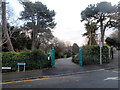
Rectory Road entrance to Alexandra Park, Penarth
This entrance, near the corner of Rectory Road and Beach Road, is at the northern edge of Penarth's first public park, created between 1899 and 1902 on sloping ground overlooking Penarth seafront.
The park was named after Alexandra of Denmark, or Queen Alexandra, the wife of King Edward VII.
Image: © Jaggery
Taken: 9 Dec 2012
0.07 miles
9
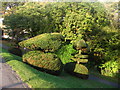
Alexandra Park Topiary
Autumn afternoon sunlight on a topiary beside a path in Alexandra Park. Houses in Rectory Road can just be seen through the trees.
Image: © David Roberts
Taken: 17 Oct 2009
0.08 miles
10
Steps from Beach Road, Penarth
Steps, part of the Wales Coast Path, next to The Kymin (right).
Image: © M J Roscoe
Taken: 30 Aug 2017
0.08 miles