1
Corner view of Barry Town Hall
Viewed across Tynewydd Road. http://www.geograph.org.uk/photo/3357758 to a front view and a potted history.
Image: © Jaggery
Taken: 28 Feb 2013
0.02 miles
2
Town hall clock tower, Barry
Viewed from King Square. See http://www.geograph.org.uk/photo/3357758 for a wider view and a potted history of the town hall.
Image: © Jaggery
Taken: 28 Feb 2013
0.02 miles
3
Ordnance Survey Flush Bracket (S9113)
This OS Flush Bracket can be found on the south face of the Library. It marks a point 33.881m above mean sea level.
Image: © Adrian Dust
Taken: 3 Feb 2018
0.02 miles
4
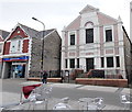
Tabernacle Welsh Congregational Chapel, Barry
The year 1894 is inscribed in stone above the central upper window of the Holton Road chapel.
Image: © Jaggery
Taken: 28 Feb 2013
0.02 miles
5
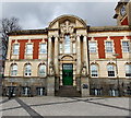
Barry Town Hall
Viewed across King Square.
The following chronology is based on information shown on the Vale of Glamorgan Council website. This site was woodland until the end of the nineteenth century.
1900 Maes y Cwm Quarry was excavated on the site of nearby Central Park.
1903 The council acquired the quarry site, which was later filled in enabling the building of Central Park and the library. In the same year, a competition was held for the design of a new block of offices for Barry Urban District Council. The Council appealed to the Andrew Carnegie Trust for a grant to enable a public library for the town to be built.
1906 The library was completed and officially opened on March 1st by The Earl of Plymouth.
1908 Town hall completed at a cost of £7,488, and officially opened on April 22nd. The provision of the clock was not part of the same contract and was supplied at a cost of £329 10s.
1910 Town Hall Square was named King Square.
1939 A Charter of Incorporation was granted and Barry Borough Council was created with its administrative centre at the town hall. This charter authorised the council to appoint a mayor of Barry for the first time.
1974 Local government reorganisation led to the formation of the Vale of Glamorgan Borough Council with its administrative centre here at the town hall.
1981 The Council Chamber at the town hall was used for the last time. The mayor and council then moved to the new Civic Office in Holton Road.
2001 Barry library relocated to a temporary home at Barry Leisure Centre.
2005 Work began on the redevelopment of the town hall, King Square and Central Park.
2006 The mayor of the Vale of Glamorgan Council moved into the refurbished town hall, using the former council chamber as the mayor's parlour.
2007 The new county library http://www.geograph.org.uk/photo/3356189 and town hall were officially opened on January 4th.
Image: © Jaggery
Taken: 28 Feb 2013
0.02 miles
6
United States military personnel dedication, Barry Town Hall
Unveiled in June 2012, the plaque is here. http://www.geograph.org.uk/photo/3379335
Image: © Jaggery
Taken: 17 Mar 2013
0.03 miles
7
Town Hall, Barry
Image: © Roger Cornfoot
Taken: 3 Apr 2017
0.03 miles
8
Boots Pharmacy, Holton Road, Barry
Located at 121-125 Holton Road, in the pedestrianised area of the road, east of King Square.
Image: © Jaggery
Taken: 28 Feb 2013
0.03 miles
9
Parade of shops on Holton Road
Image: © Roger Cornfoot
Taken: 3 Apr 2017
0.03 miles
10
Western side of Barry Town Hall
Viewed from King Square. See http://www.geograph.org.uk/photo/3357758 for a wider view and some details.
Beneath the stone lion on the right, there is a plaque http://www.geograph.org.uk/photo/3379340 dedicated to the memory of the United States military personnel stationed in and around Barry 1942-1945.
Image: © Jaggery
Taken: 17 Mar 2013
0.03 miles


