IMAGES TAKEN NEAR TO
Station Street, BARRY, CF63 4LZ
Introduction
This page details the photographs taken nearby to Station Street, CF63 4LZ by members of the Geograph project.
The Geograph project started in 2005 with the aim of publishing, organising and preserving representative images for every square kilometre of Great Britain, Ireland and the Isle of Man.

There are currently over 7.5m images from over14,400 individuals and you can help contribute to the project by visiting https://www.geograph.org.uk
Image Map
Images are licensed for reuse under creativecommons.org/licenses/by-sa/2.0
Notes
- Clicking on the map will re-center to the selected point.
- The higher the marker number, the further away the image location is from the centre of the postcode.
Image Listing (187 Images Found)
Images are licensed for reuse under creativecommons.org/licenses/by-sa/2.0
Image
Details
Distance
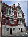
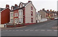
1
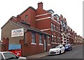
Barry Dock Constitutional Club, Barry
Located at the southern end of Station Street, near the Dock View Road junction.
Image: © Jaggery
Taken: 28 Feb 2013
0.01 miles
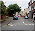
2
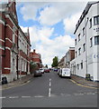
Station Street, Barry
Ascending from Dock View Road towards Cross Street.
This entrance path http://www.geograph.org.uk/photo/5083752 to Barry Docks railway station is nearby.
Image: © Jaggery
Taken: 26 Apr 2017
0.01 miles
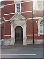
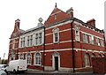
3
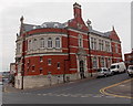
Former Custom House & Mercantile Marine Offices, Barry
Now in use as flats, this substantial building occupies the corner of Station Street and Dock View Road. An inscription http://www.geograph.org.uk/photo/1897278 above the doorway records its former use. Built between 1901 and 1910, Grade II listed in 1990.
Image: © Jaggery
Taken: 28 Feb 2013
0.03 miles
6
Kingsland Crescent, Barry
Ascending from the north side of Dock View Road.
Image: © Jaggery
Taken: 18 Aug 2016
0.04 miles
7
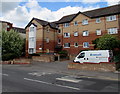
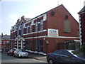
Campbell Court, Barry
Campbell Court flats viewed across Dock View Road.
Image: © Jaggery
Taken: 26 Apr 2017
0.04 miles
8
Custom House, Barry, Dock View Rd frontage
Stone carving of the royal coat of arms above the bay window
Image: © John Lord
Taken: 4 Jun 2010
0.04 miles
9
Corner of Dock View Road and St Mary's Avenue, Barry
St Mary's Avenue climbs away from Dock View Road.
Image: © Jaggery
Taken: 28 Feb 2013
0.05 miles
10
Station Street side of the former Custom House, Barry
The former Custom House & Mercantile Marine Offices http://www.geograph.org.uk/photo/3359052 are now in use as flats.
Image: © Jaggery
Taken: 28 Feb 2013
0.05 miles