IMAGES TAKEN NEAR TO
Holton Road, BARRY, CF63 4HW
Introduction
This page details the photographs taken nearby to Holton Road, CF63 4HW by members of the Geograph project.
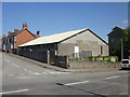
The Geograph project started in 2005 with the aim of publishing, organising and preserving representative images for every square kilometre of Great Britain, Ireland and the Isle of Man.

There are currently over 7.5m images from over14,400 individuals and you can help contribute to the project by visiting https://www.geograph.org.uk
Image Map
Images are licensed for reuse under creativecommons.org/licenses/by-sa/2.0
Notes
- Clicking on the map will re-center to the selected point.
- The higher the marker number, the further away the image location is from the centre of the postcode.
Image Listing (124 Images Found)
Images are licensed for reuse under creativecommons.org/licenses/by-sa/2.0
Image
Details
Distance
1
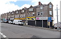
Long row of shops, Holton Road, Barry
The row of shops extends for 65 metres along Holton Road, from the corner of Burlington Street on the right to the corner of Robert Street on the left. The three shops nearest the corner are Ability Living & Mobility, Strickly Roots Authentic Caribbean Cuisine and Bassett General Stores.
Image: © Jaggery
Taken: 17 Mar 2013
0.00 miles
3
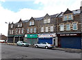
Barry Computer Centre, Holton Road, Barry
Barry Computer Centre is at 294 Holton Road. Next door on the right is Bassett Park Barbers.
The right turn ahead past the edge of the shops is into Robert Street. http://www.geograph.org.uk/photo/3373999
Image: © Jaggery
Taken: 17 Mar 2013
0.01 miles
4
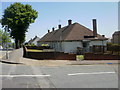
Bungalows, Holton Road, Barry
A block of bungalows with low-pitched roofs occupy a rectangle of land on the south side of Holton Road, between Robert Street and Wilfred Street.
Image: © Jaggery
Taken: 16 Jun 2010
0.02 miles
5
Sea Scouts premises, Barry
Premises of the 5th Barry (Holton Road Baptist) Sea Scouts, located on the corner of Holton Road and Everard Street. The building was originally a 'tin church' erected at Harbour Road for Bethel Baptists.
A prefabricated structure of wood and corrugated iron, it dates from 1893. When the congregation outgrew the building, it was taken down and re-erected here.
Image: © Jaggery
Taken: 16 Jun 2010
0.02 miles
6
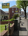
Plaid Cymru placards on display in Holton Road, Barry
On display in late April 2017. Local council elections will take place in early May 2017, followed by the UK General Election on Thursday June 8th 2017. Plaid Cymru (The Party of Wales) was formed on August 5th 1925.
Image: © Jaggery
Taken: 26 Apr 2017
0.03 miles
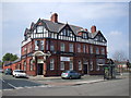
7
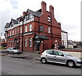
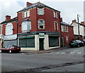
The Tadross Hotel, Barry
The hotel is at 271 Holton Road, on the corner of Bassett Street.
The entrance to the hotel's Bassett Bar is at the left (Bassett Street) corner, seen in this http://www.geograph.org.uk/photo/1897249 view.
Image: © Jaggery
Taken: 17 Mar 2013
0.03 miles
8
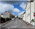
Robert Street, Barry
Robert Street ascends from Dock View Road towards Holton Road.
Image: © Jaggery
Taken: 26 Apr 2017
0.03 miles
9
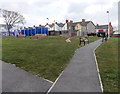
Bassett Park, Barry
Viewed from the Holton Road entrance. Bassett Park is located between Bassett Street and Everard Street, to the east of Barry town centre. Welsh Government funding of £400,000 through the Barry Regeneration Area programme has transformed the open space into a new play and recreation area.
Image: © Jaggery
Taken: 17 Mar 2013
0.03 miles
10
Bite Me, Barry
Bite Me is a reptiles and other exotic pets shop on the corner of Holton Road and Bassett Street.
Next door is The Barry Music Shop.
Image: © Jaggery
Taken: 17 Mar 2013
0.04 miles