IMAGES TAKEN NEAR TO
Woodlands Road, BARRY, CF63 4EF
Introduction
This page details the photographs taken nearby to Woodlands Road, CF63 4EF by members of the Geograph project.
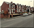
The Geograph project started in 2005 with the aim of publishing, organising and preserving representative images for every square kilometre of Great Britain, Ireland and the Isle of Man.

There are currently over 7.5m images from over14,400 individuals and you can help contribute to the project by visiting https://www.geograph.org.uk
Image Map
Images are licensed for reuse under creativecommons.org/licenses/by-sa/2.0
Notes
- Clicking on the map will re-center to the selected point.
- The higher the marker number, the further away the image location is from the centre of the postcode.
Image Listing (125 Images Found)
Images are licensed for reuse under creativecommons.org/licenses/by-sa/2.0
Image
Details
Distance
1
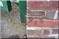
Ordnance Survey Cut Mark
This OS cut mark can be found on St Helens Road School. It marks a point 46.942m above mean sea level.
Image: © Adrian Dust
Taken: 3 Feb 2018
0.05 miles
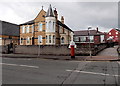
2
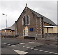
St Helen's RC church Barry viewed from the SE
Viewed across Wyndham Street. The Roman Catholic church dates from 1907.
Image: © Jaggery
Taken: 17 Mar 2013
0.06 miles
3
St Helen's RC church Barry viewed from the SW
Viewed across Wyndham Street. The Roman Catholic church dates from 1907.
Image: © Jaggery
Taken: 17 Mar 2013
0.06 miles
4
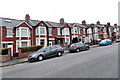
Gladstone Road houses, Barry
The houses are on the south side of Gladstone Road, between Belmont Street and Glencoe Street.
Image: © Jaggery
Taken: 28 Feb 2013
0.06 miles
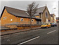
5
St Helen's presbytery and war memorial, Barry
The presbytery (priests' house) for St Helen's RC church is located on the corner of Wyndham Street and Court Road. There is a war memorial in the form of a calvary http://www.geograph.org.uk/photo/3379262 in the grounds of the presbytery.
Image: © Jaggery
Taken: 17 Mar 2013
0.07 miles
6
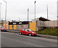
Entrance to Jenner Park Stadium, Barry
Viewed across Gladstone Road. Jenner Park http://www.geograph.org.uk/photo/3355936 is the home ground of Barry Town football club.
Image: © Jaggery
Taken: 28 Feb 2013
0.07 miles
7
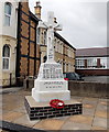
St Helen's RC War Memorial, Barry
The War Memorial in the form of a calvary is located in front of St Helen's presbytery http://www.geograph.org.uk/photo/3379250
on the corner of Wyndham Street and Court Road. The dedication on the face in view
is to the men of the parish who sacrificed their lives in the Great War (1914-1918).
Image: © Jaggery
Taken: 17 Mar 2013
0.07 miles
8
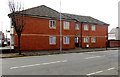
Cambrian Court, Barry
Located in Wyndham Street near the corner of Court Road, Cambrian Court contains 6 flats.
Image: © Jaggery
Taken: 17 Mar 2013
0.08 miles
9
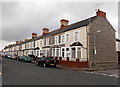
Long row of houses, Pyke Street, Barry
Viewed from the corner of Crossways Street.
The row of 25 houses on the east side of Pyke Street extends for 140 metres.
Image: © Jaggery
Taken: 17 Mar 2013
0.09 miles
10
Gladstone Road houses west of Glencoe Street, Barry
The houses are on the south side of Gladstone Road, viewed from opposite Glencoe Street.
Image: © Jaggery
Taken: 28 Feb 2013
0.09 miles