IMAGES TAKEN NEAR TO
Y Rhodfa, BARRY, CF63 4BD
Introduction
This page details the photographs taken nearby to Y Rhodfa, CF63 4BD by members of the Geograph project.
The Geograph project started in 2005 with the aim of publishing, organising and preserving representative images for every square kilometre of Great Britain, Ireland and the Isle of Man.

There are currently over 7.5m images from over14,400 individuals and you can help contribute to the project by visiting https://www.geograph.org.uk
Image Map
Images are licensed for reuse under creativecommons.org/licenses/by-sa/2.0
Notes
- Clicking on the map will re-center to the selected point.
- The higher the marker number, the further away the image location is from the centre of the postcode.
Image Listing (133 Images Found)
Images are licensed for reuse under creativecommons.org/licenses/by-sa/2.0
Image
Details
Distance
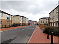
2
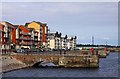
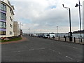
Y Rhodfa, Barry
The Wales Coast Path goes along here, with attractive apartments overlooking the docks.
Image: © Eirian Evans
Taken: 23 Jun 2021
0.03 miles
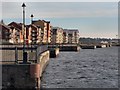
3
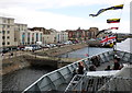
Dockside apartments, viewed from the upper deck, HMS Tyne
Image: © Roger Cornfoot
Taken: 3 Sep 2011
0.03 miles
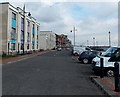
4
Y Rhodfa, Barry
A view east along the edge of Barry Docks.
Image: © Jaggery
Taken: 17 Mar 2013
0.04 miles
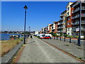
6
Y Rhodfa, Barry
Looking east along the waterfront at the northern edge of Barry Dock.
Image: © Jaggery
Taken: 17 Mar 2013
0.06 miles
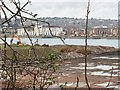
7
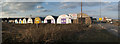
Workshops, Barry Dock
There are several rows of similar workshops behind these ones.
Image: © Guy Butler-Madden
Taken: 3 Apr 2013
0.06 miles
8
Heol y Llongau houses, Barry
Viewed looking toward Heol y Porthladd.
Image: © Jaggery
Taken: 17 Mar 2013
0.06 miles
9
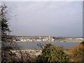
View across Barry Docks
From Clive Rd, Barry Island.
Image: © John Lord
Taken: 22 Mar 2011
0.07 miles