IMAGES TAKEN NEAR TO
Heol Y Porthladd, BARRY, CF63 4AP
Introduction
This page details the photographs taken nearby to Heol Y Porthladd, CF63 4AP by members of the Geograph project.
The Geograph project started in 2005 with the aim of publishing, organising and preserving representative images for every square kilometre of Great Britain, Ireland and the Isle of Man.

There are currently over 7.5m images from over14,400 individuals and you can help contribute to the project by visiting https://www.geograph.org.uk
Image Map
Images are licensed for reuse under creativecommons.org/licenses/by-sa/2.0
Notes
- Clicking on the map will re-center to the selected point.
- The higher the marker number, the further away the image location is from the centre of the postcode.
Image Listing (179 Images Found)
Images are licensed for reuse under creativecommons.org/licenses/by-sa/2.0
Image
Details
Distance
1
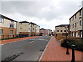
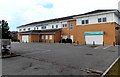
Heol y Llongau houses, Barry
Viewed looking toward Heol y Porthladd.
Image: © Jaggery
Taken: 17 Mar 2013
0.02 miles
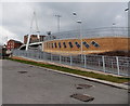
2
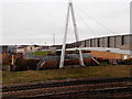
Western side of Thompson Street footbridge, Barry
This end is at the junction of Thompson Street and Dock View Road. The bridge, which crosses to the Waterfront over railway lines, was officially opened to the public in December 2009. Its construction was funded by Barry Council with support from the Welsh Assembly Government and Associated British Ports. The bridge was designed by Parsons Brinkerhoff and built by Carillion.
Image: © Jaggery
Taken: 6 Jan 2013
0.03 miles
3
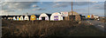
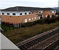
Workshops, Barry Dock
There are several rows of similar workshops behind these ones.
Image: © Guy Butler-Madden
Taken: 3 Apr 2013
0.05 miles
4
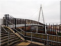
Eastern side of Thompson Street footbridge, Barry
This end is at the junction of Thompson Street and Dock View Road. The bridge, which crosses to the Waterfront over railway lines, was officially opened to the public in December 2009. Its construction was funded by Barry Council with support from the Welsh Assembly Government and Associated British Ports. The bridge was designed by Parsons Brinkerhoff and built by Carillion.
Image: © Jaggery
Taken: 6 Jan 2013
0.05 miles
5
Waterfront Medical Centre and Lloyds Pharmacy, Barry
Viewed from Heol Y Llongau.
Image: © Jaggery
Taken: 17 Mar 2013
0.05 miles
6
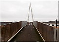
Across Thompson Street footbridge, Barry
Looking towards the Waterfront. http://www.geograph.org.uk/photo/3319529 to a side view and some details.
Image: © Jaggery
Taken: 6 Jan 2013
0.05 miles
7
Waterfront Medical Centre, Barry
Viewed from this http://www.geograph.org.uk/photo/3319533 footbridge. The medical centre is in Heol Y Llongau.
The railway is between Barry station and Barry Docks station.
Image: © Jaggery
Taken: 6 Jan 2013
0.06 miles
8
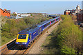
High Speed Train near Barry Docks
A diverted High Speed Train near Barry Docks.
Image: © Wayland Smith
Taken: 13 Apr 2014
0.06 miles
9
Thompson Street footbridge viewed from the south, Barry
This view of the footbridge http://www.geograph.org.uk/photo/3319533 is from Heol y Llongau.
Image: © Jaggery
Taken: 17 Mar 2013
0.07 miles
10
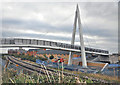
Footbridge under construction - Barry
The bridge will link the development along the old dock area with the town and its facilities. The main shopping area is nearby as are the council offices and leisure centre.
Image: © Mick Lobb
Taken: 28 Sep 2009
0.07 miles