IMAGES TAKEN NEAR TO
Atlantic Crescent, BARRY, CF63 3RG
Introduction
This page details the photographs taken nearby to Atlantic Crescent, CF63 3RG by members of the Geograph project.
The Geograph project started in 2005 with the aim of publishing, organising and preserving representative images for every square kilometre of Great Britain, Ireland and the Isle of Man.

There are currently over 7.5m images from over14,400 individuals and you can help contribute to the project by visiting https://www.geograph.org.uk
Image Map
Images are licensed for reuse under creativecommons.org/licenses/by-sa/2.0
Notes
- Clicking on the map will re-center to the selected point.
- The higher the marker number, the further away the image location is from the centre of the postcode.
Image Listing (6 Images Found)
Images are licensed for reuse under creativecommons.org/licenses/by-sa/2.0
Image
Details
Distance
1

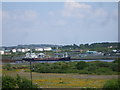
American Diner, Barry Docks
A bright spot in an otherwise drab scene. I wonder if the waitress really looks like that . . .
Image: © Antony Dixon
Taken: 22 Nov 2011
0.14 miles
2
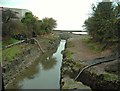
Journey's end
Cadoxton River nears the end of its journey to the sea.
Image: © Antony Dixon
Taken: 22 Nov 2011
0.15 miles
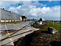
4
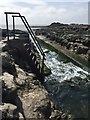
Riverside Steps
Staircase to the Cadoxton river near its discharge into the Bristol Channel close to Bendrick Rock.
Image: © Alan Hughes
Taken: 7 Jul 2017
0.20 miles
5
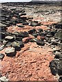
Red Siltstone
Red siltstone from the late Triassic period contrasts in colour with the blocks of carboniferous limestone.
Image: © Alan Hughes
Taken: 7 Jul 2017
0.21 miles
6
Railway line into Barry docks
Viewed from David Davies Road. The single-track railway line, from the main line behind the camera, heads into Barry docks.
Image: © Jaggery
Taken: 17 Mar 2013
0.25 miles