IMAGES TAKEN NEAR TO
Radnor Green, BARRY, CF62 9AR
Introduction
This page details the photographs taken nearby to Radnor Green, CF62 9AR by members of the Geograph project.
The Geograph project started in 2005 with the aim of publishing, organising and preserving representative images for every square kilometre of Great Britain, Ireland and the Isle of Man.

There are currently over 7.5m images from over14,400 individuals and you can help contribute to the project by visiting https://www.geograph.org.uk
Image Map
Images are licensed for reuse under creativecommons.org/licenses/by-sa/2.0
Notes
- Clicking on the map will re-center to the selected point.
- The higher the marker number, the further away the image location is from the centre of the postcode.
Image Listing (11 Images Found)
Images are licensed for reuse under creativecommons.org/licenses/by-sa/2.0
Image
Details
Distance
1
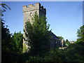
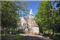
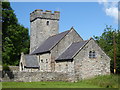
Church of St Dyfan & St Teilo, Merthyr Dyfan
Image: © John Lord
Taken: 23 May 2010
0.17 miles
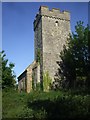
3
Church of St Dyfan & St Teilo, Merthyr Dyfan
Image: © John Lord
Taken: 23 May 2010
0.19 miles
4
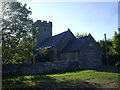
Church of St Dyfan & St Teilo, Merthyr Dyfan
Image: © John Lord
Taken: 23 May 2010
0.19 miles
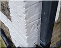
5
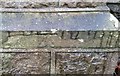
Ordnance Survey Cut Mark
This OS cut mark can be found on a cemetery wall post at its entrance. It marks a point 78.931m above mean sea level.
Image: © Adrian Dust
Taken: 3 Feb 2018
0.19 miles
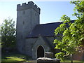
8
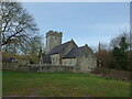
Church St Dyfan and St Teilo, Barry
C13 nave and chancel, C16 W tower, restoration of 1857 added porch, and altered windows. Restoration of tower in 1909 and other parts of church in 1970s.
Grade II* listed by Cadw as an almost complete medieval building.
Image: © Colin Cheesman
Taken: 24 Mar 2021
0.23 miles
10
Ordnance Survey Cut Mark
This OS cut mark can be found on No215 Barry Road. It marks a point 72.942m above mean sea level.
Image: © Adrian Dust
Taken: 3 Feb 2018
0.24 miles