IMAGES TAKEN NEAR TO
Port Road West, BARRY, CF62 8ZJ
Introduction
This page details the photographs taken nearby to Port Road West, CF62 8ZJ by members of the Geograph project.
The Geograph project started in 2005 with the aim of publishing, organising and preserving representative images for every square kilometre of Great Britain, Ireland and the Isle of Man.

There are currently over 7.5m images from over14,400 individuals and you can help contribute to the project by visiting https://www.geograph.org.uk
Image Map
Images are licensed for reuse under creativecommons.org/licenses/by-sa/2.0
Notes
- Clicking on the map will re-center to the selected point.
- The higher the marker number, the further away the image location is from the centre of the postcode.
Image Listing (29 Images Found)
Images are licensed for reuse under creativecommons.org/licenses/by-sa/2.0
Image
Details
Distance
1
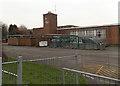
Clock tower, Barry Comprehensive School
Viewed from Port Road West. Situated at the northern edge of Barry, the school has a boys-only section (ages 11-16) and a co-educational 6th form (ages 16-18).
Image: © Jaggery
Taken: 6 Jan 2013
0.02 miles
2

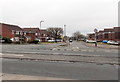
Vehicular entrance to Barry Comprehensive School
The entrance is from Port Road West. Red signs state Please drive carefully, No Dogs and No Cycling.
Image: © Jaggery
Taken: 6 Jan 2013
0.02 miles
3
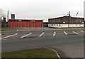
Barry Fire Station
The fire station was built in 1978 on the north side of Port Road West, in the Colcot area in the north of Barry. The station, part of the South Wales Fire and Rescue service, covers an area in the Vale of Glamorgan with a population of c48,000. This area includes the town of Barry, as well as Cardiff International Airport at Rhoose, several large chemical plants and a power station.
Image: © Jaggery
Taken: 6 Jan 2013
0.08 miles
4
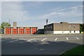
Barry Fire Station
Barry Fire Station, Port Road West, Barry
Image: © Kevin Hale
Taken: 5 Jun 2007
0.09 miles
5

Highlight Lane, Barry
Viewed across Port Road West. Now part of a housing estate built in the 1970s, Highlight Lane
formerly ran through open countryside to Highlight Farm, which is more than five hundred years old.
Image: © Jaggery
Taken: 6 Jan 2013
0.10 miles
6
Liscum Way, Barry
Viewed across Port Road West.
Liscum Way is in an area of modern houses in the Colcot area in the north of Barry.
Image: © Jaggery
Taken: 6 Jan 2013
0.10 miles
7
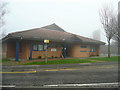
Highlight Park Community Centre
In the northern suburbs of Barry.
The tower of Barry Fire Station can be seen through the December mist beyond.
Image: © Jonathan Billinger
Taken: 11 Dec 2009
0.10 miles
8
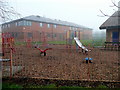
Play area, Colcot
Safe facilities adjacent to the Highlight Park Community Centre.
Image: © Jonathan Billinger
Taken: 11 Dec 2009
0.10 miles
9
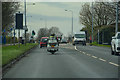
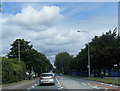
Barry : Port Road West A4226
Heading along Port Road West.
Image: © Lewis Clarke
Taken: 23 Mar 2019
0.11 miles