IMAGES TAKEN NEAR TO
Gladstone Road, BARRY, CF62 8NB
Introduction
This page details the photographs taken nearby to Gladstone Road, CF62 8NB by members of the Geograph project.
The Geograph project started in 2005 with the aim of publishing, organising and preserving representative images for every square kilometre of Great Britain, Ireland and the Isle of Man.

There are currently over 7.5m images from over14,400 individuals and you can help contribute to the project by visiting https://www.geograph.org.uk
Image Map (Loading...)


Getting Data...Please wait
Leaflet Map data © OpenStreetMap
Images are licensed for reuse under creativecommons.org/licenses/by-sa/2.0
Notes
- Clicking on the map will re-center to the selected point.
- The higher the marker number, the further away the image location is from the centre of the postcode.
Image Listing (87 Images Found)
Images are licensed for reuse under creativecommons.org/licenses/by-sa/2.0
Image
Details
Distance
1
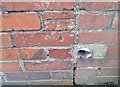
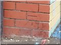
Ordnance Survey Cut Mark
This OS cut mark can be found on No214 Gladstone Road. It marks a point 44.714m above mean sea level.
Image: © Adrian Dust
Taken: 3 Feb 2018
0.08 miles
2
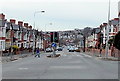
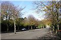
Gladstone Road west of Ty-newydd Road, Barry
Viewed from the Ty-newydd Road crossroads. Gladstone Road descends
towards the Barry Dock and Barry Waterfront areas of the town.
Image: © Jaggery
Taken: 28 Feb 2013
0.08 miles
3
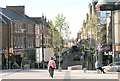
Holton Road, Barry
Viewed from Kings Square
Image: © Tony Hodge
Taken: 2 Nov 2006
0.10 miles
4
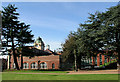
Barry Town Hall and new Library
The east elevation taken from Central Park. The new library is the wing to the right
Image: © Tony Hodge
Taken: 2 Nov 2006
0.10 miles
5
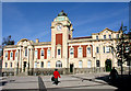
Barry Town Hall
This fine Edwardian building which has been unused for a number of years has recently been extensively refurbished. The part to the left was the Town Hall and to the right the Library. A wing to house a new library has been added.
Image: © Tony Hodge
Taken: 2 Nov 2006
0.10 miles
6
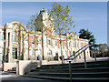
Barry Town Hall
Newly refurbished fine Edwardian civic building
Image: © Tony Hodge
Taken: 2 Nov 2006
0.10 miles
10
Ordnance Survey Cut Mark
This OS cut mark can be found on the school building, Gladstone Street It marks a point 33.491m above mean sea level.
Image: © Adrian Dust
Taken: 3 Feb 2018
0.10 miles