IMAGES TAKEN NEAR TO
Lowdon Terrace, BARRY, CF62 8JH
Introduction
This page details the photographs taken nearby to Lowdon Terrace, CF62 8JH by members of the Geograph project.
The Geograph project started in 2005 with the aim of publishing, organising and preserving representative images for every square kilometre of Great Britain, Ireland and the Isle of Man.

There are currently over 7.5m images from over14,400 individuals and you can help contribute to the project by visiting https://www.geograph.org.uk
Image Map
Images are licensed for reuse under creativecommons.org/licenses/by-sa/2.0
Notes
- Clicking on the map will re-center to the selected point.
- The higher the marker number, the further away the image location is from the centre of the postcode.
Image Listing (96 Images Found)
Images are licensed for reuse under creativecommons.org/licenses/by-sa/2.0
Image
Details
Distance
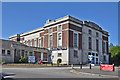
2
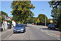
Llandinam Road, Barry
Viewed across College Road.
Image: © Jaggery
Taken: 6 Jan 2013
0.08 miles
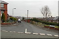
3
Junction of Gladstone and Buttrills Road and St Paul's Avenue - Barry
Image: © Mick Lobb
Taken: 9 Sep 2009
0.08 miles
4
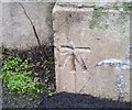
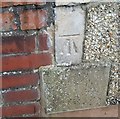
Ordnance Survey Cut Mark
This OS cut mark can be found on the wall adjacent the seating area on Gladstone Road. It marks a point 30.300m above mean sea level.
Image: © Adrian Dust
Taken: 3 Feb 2018
0.09 miles
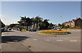
5
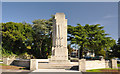
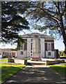
War Memorial - Barry
A view of the opposite face of that shown in Image that shows its Welsh inscription.
Image: © Mick Lobb
Taken: 9 Sep 2009
0.10 miles
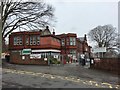
7
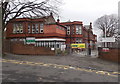
Ysgol Sant Curig, Barry
Viewed across College Road. Ysgol Sant Curig is a Welsh medium primary school, where Welsh is the main medium of education. English is introduced as a subject in Year 3. The aim is for all pupils to be fluent in both Welsh and English before transferring to secondary school at the age of 11.
Image: © Jaggery
Taken: 6 Jan 2013
0.11 miles
8
Ordnance Survey Cut Mark
This OS cut mark can be found on No35 Buttrills Road. It marks a point 59.460m above mean sea level.
Image: © Adrian Dust
Taken: 3 Feb 2018
0.11 miles
10
Ysgol Sant Curig
Welsh language Junior School, Barry.
Image: © Alan Hughes
Taken: 8 Mar 2017
0.11 miles