IMAGES TAKEN NEAR TO
Glyndwr Road, BARRY, CF62 8HY
Introduction
This page details the photographs taken nearby to Glyndwr Road, CF62 8HY by members of the Geograph project.
The Geograph project started in 2005 with the aim of publishing, organising and preserving representative images for every square kilometre of Great Britain, Ireland and the Isle of Man.

There are currently over 7.5m images from over14,400 individuals and you can help contribute to the project by visiting https://www.geograph.org.uk
Image Map
Images are licensed for reuse under creativecommons.org/licenses/by-sa/2.0
Notes
- Clicking on the map will re-center to the selected point.
- The higher the marker number, the further away the image location is from the centre of the postcode.
Image Listing (89 Images Found)
Images are licensed for reuse under creativecommons.org/licenses/by-sa/2.0
Image
Details
Distance
1
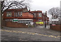
Ysgol Sant Curig, Barry
Viewed across College Road. Ysgol Sant Curig is a Welsh medium primary school, where Welsh is the main medium of education. English is introduced as a subject in Year 3. The aim is for all pupils to be fluent in both Welsh and English before transferring to secondary school at the age of 11.
Image: © Jaggery
Taken: 6 Jan 2013
0.07 miles
2
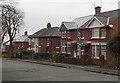
College Road houses, Barry
These houses face a Welsh medium primary school, Ysgol Sant Curig. http://www.geograph.org.uk/photo/3296373
Image: © Jaggery
Taken: 6 Jan 2013
0.07 miles
3
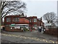
Ysgol Sant Curig
Welsh language Junior School, Barry.
Image: © Alan Hughes
Taken: 8 Mar 2017
0.07 miles
4
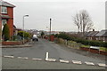
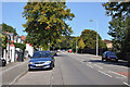
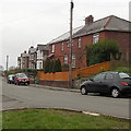
Llandinam Road, Barry
Viewed across College Road.
Image: © Jaggery
Taken: 6 Jan 2013
0.07 miles
6
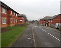
Maes-yr-ysgol, Barry
Modern housing viewed from the College Road end of Maes-yr-ysgol.
Image: © Jaggery
Taken: 6 Jan 2013
0.10 miles
7
Southern end of College Road, Barry
Viewed from the Broad Street end opposite F.J.Tyres http://www.geograph.org.uk/photo/3300424 looking towards St Paul's Avenue.
Image: © Jaggery
Taken: 6 Jan 2013
0.11 miles
8
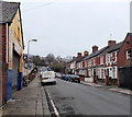
Down College Road, Barry
College Road descends away from the Jenner Road junction.
Image: © Jaggery
Taken: 6 Jan 2013
0.11 miles
9
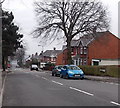
College Place houses, Barry
Viewed from the grass triangle at the junction of College Road and College Place.
Image: © Jaggery
Taken: 6 Jan 2013
0.11 miles
10
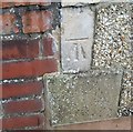
Ordnance Survey Cut Mark
This OS cut mark can be found on No35 Buttrills Road. It marks a point 59.460m above mean sea level.
Image: © Adrian Dust
Taken: 3 Feb 2018
0.11 miles