IMAGES TAKEN NEAR TO
Peterswell Road, BARRY, CF62 7NB
Introduction
This page details the photographs taken nearby to Peterswell Road, CF62 7NB by members of the Geograph project.
The Geograph project started in 2005 with the aim of publishing, organising and preserving representative images for every square kilometre of Great Britain, Ireland and the Isle of Man.

There are currently over 7.5m images from over14,400 individuals and you can help contribute to the project by visiting https://www.geograph.org.uk
Image Map (Loading...)


Getting Data...Please wait
Leaflet Map data © OpenStreetMap
Images are licensed for reuse under creativecommons.org/licenses/by-sa/2.0
Notes
- Clicking on the map will re-center to the selected point.
- The higher the marker number, the further away the image location is from the centre of the postcode.
Image Listing (5 Images Found)
Images are licensed for reuse under creativecommons.org/licenses/by-sa/2.0
Image
Details
Distance
1
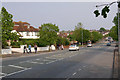
Pontypridd Road, Barry
The B4266, one of the many wide roads laid out by Barry's farsighted planners.
Image: © Christopher R Ware
Taken: 28 Mar 2007
0.09 miles
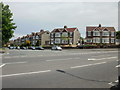
2
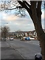
Pontypridd Road
Housing on Pontypridd Road, Barry.
Image: © Alan Hughes
Taken: 29 Dec 2016
0.11 miles
3
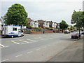
Twin bungalows, Pontypridd Road, Barry
Matching pairs of bungalows on the section of Pontypridd Road between Severn Avenue and Peterswell Road.
Image: © Jaggery
Taken: 6 Jun 2010
0.15 miles
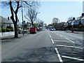
5
Corner of Claude Road West and Pontypridd Road, Barry
Houses form a curve at the corner of Claude Road West and Pontypridd Road.
Image: © Jaggery
Taken: 6 Jun 2010
0.24 miles