IMAGES TAKEN NEAR TO
Jenner Road, BARRY, CF62 7HS
Introduction
This page details the photographs taken nearby to Jenner Road, CF62 7HS by members of the Geograph project.
The Geograph project started in 2005 with the aim of publishing, organising and preserving representative images for every square kilometre of Great Britain, Ireland and the Isle of Man.

There are currently over 7.5m images from over14,400 individuals and you can help contribute to the project by visiting https://www.geograph.org.uk
Image Map
Images are licensed for reuse under creativecommons.org/licenses/by-sa/2.0
Notes
- Clicking on the map will re-center to the selected point.
- The higher the marker number, the further away the image location is from the centre of the postcode.
Image Listing (88 Images Found)
Images are licensed for reuse under creativecommons.org/licenses/by-sa/2.0
Image
Details
Distance
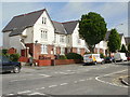
1
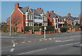
Houses at the SW end of Jenner Road, Barry
This is the corner of Jenner Road and Pontypridd Road.
Image: © Jaggery
Taken: 5 Mar 2013
0.05 miles
2
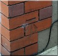
Ordnance Survey Cut Mark
This OS cut mark can be found on No146 Jenner Road. It marks a point 67.173m above mean sea level.
Image: © Adrian Dust
Taken: 28 Feb 2018
0.05 miles
3
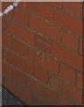
Ordnance Survey Cut Mark
This OS cut mark can be found on the NW angle of the school. It marks a point 63.072m above mean sea level.
Image: © Adrian Dust
Taken: 28 Feb 2018
0.11 miles
4
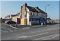
Crescent Corner Newsagents, Barry
The shop is on the corner of Park Crescent and Gaen Street.
Image: © Jaggery
Taken: 5 Mar 2013
0.11 miles
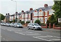
5
Jenner Road, Barry
Houses on Jenner Road, viewed from the corner of Trinity Street.
Image: © Jaggery
Taken: 6 Jun 2010
0.11 miles
6
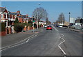
Jenner Road, Barry
A view to NE along the A4050 Jenner Road from the junction of Pontypridd Road and Park Crescent.
Image: © Jaggery
Taken: 5 Mar 2013
0.11 miles
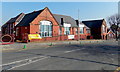
7
Romilly Primary School, Barry
On the corner of Park Crescent and Romilly Road.
Image: © Jaggery
Taken: 5 Mar 2013
0.12 miles
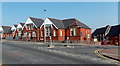
8
Approaching the southwest end of Jenner Road, Barry
Houses on the northwest side of Jenner Road, with a line of grey (or silver) cars parked outside.
Image: © Jaggery
Taken: 6 Jun 2010
0.12 miles
9
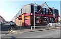
A Sainsbury's Local in Barry
On the corner of Park Crescent and Kathleen Street.
Image: © Jaggery
Taken: 5 Mar 2013
0.12 miles
10
Part of Romilly Primary School used for Sunday worship by Bethel Baptist Church, Barry
Viewed across Romilly Road. A yellow Welcome banner on the fence shows that
the Bethel Baptist Church congregation worships here (on Sunday mornings).
The church building http://www.geograph.org.uk/photo/3361919 on the corner of Harbour Road and St Nicholas Road
is used for Sunday evening worship.
Image: © Jaggery
Taken: 5 Mar 2013
0.14 miles