IMAGES TAKEN NEAR TO
Porthkerry Road, BARRY, CF62 7ER
Introduction
This page details the photographs taken nearby to Porthkerry Road, CF62 7ER by members of the Geograph project.
The Geograph project started in 2005 with the aim of publishing, organising and preserving representative images for every square kilometre of Great Britain, Ireland and the Isle of Man.

There are currently over 7.5m images from over14,400 individuals and you can help contribute to the project by visiting https://www.geograph.org.uk
Image Map
Images are licensed for reuse under creativecommons.org/licenses/by-sa/2.0
Notes
- Clicking on the map will re-center to the selected point.
- The higher the marker number, the further away the image location is from the centre of the postcode.
Image Listing (182 Images Found)
Images are licensed for reuse under creativecommons.org/licenses/by-sa/2.0
Image
Details
Distance
1
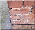
Ordnance Survey Cut Mark
This OS cut mark can be found on No37 Princes Street. It marks a point 32.242m above mean sea level.
Image: © Adrian Dust
Taken: 28 Feb 2018
0.02 miles
2
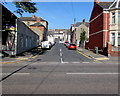
East Street, Barry
From the A4055 Broad Street along East Street towards High Street, Queen Street and Princes Street.
Image: © Jaggery
Taken: 8 Sep 2019
0.09 miles
3
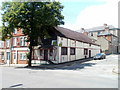
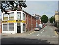
Former Four Lanterns restaurant, Barry
Located on the corner of Broad Street and East Street, the building is currently empty and available to let. Its previous uses include the Four Lanterns restaurant and a billiard hall. It was originally a church, dating from the 1890s.
Image: © Jaggery
Taken: 9 Jul 2011
0.10 miles
4
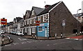
Eastern end of High Street, Barry
Viewed across Trinity Street from St Paul's Avenue.
Image: © Jaggery
Taken: 6 Jan 2013
0.11 miles
5
Trinity Street, Barry
Trinity Street climbs away from the junction of High Street and St Paul's Avenue, towards Jenner Road.
Image: © Jaggery
Taken: 6 Jan 2013
0.11 miles
6
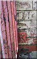
Ordnance Survey Cut Mark
This almost hidden OS cut mark can be found on the NE angle of The Four Lanterns. It marks a point 22.116m above mean sea level.
Image: © Adrian Dust
Taken: 28 Feb 2018
0.11 miles
7
Trinity Street, Barry
The view from the corner of Broad Street.
Image: © Jaggery
Taken: 6 Jun 2010
0.11 miles
8
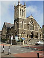
Holy Trinity Presbyterian Church, Barry
Located on the corner of Trinity Street and St Paul's Avenue, viewed from the eastern edge of High Street. The first services were held in June 1895
Image: © Jaggery
Taken: 6 Jun 2010
0.11 miles
9
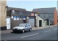
Sims Garage, Barry
Located on Trinity Street, near the Broad Street junction.
Image: © Jaggery
Taken: 9 Jul 2011
0.11 miles
10
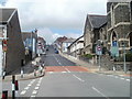
Trinity Street, Barry
Trinity Street climbs away from Holy Trinity Presbyterian Church. http://www.geograph.org.uk/photo/1905053
The No Entry sign on the left is at the edge of High Street.
Image: © Jaggery
Taken: 9 Jul 2011
0.11 miles