IMAGES TAKEN NEAR TO
Broad Street, BARRY, CF62 7AT
Introduction
This page details the photographs taken nearby to Broad Street, CF62 7AT by members of the Geograph project.
The Geograph project started in 2005 with the aim of publishing, organising and preserving representative images for every square kilometre of Great Britain, Ireland and the Isle of Man.

There are currently over 7.5m images from over14,400 individuals and you can help contribute to the project by visiting https://www.geograph.org.uk
Image Map (Loading...)


Getting Data...Please wait
Leaflet Map data © OpenStreetMap
Images are licensed for reuse under creativecommons.org/licenses/by-sa/2.0
Notes
- Clicking on the map will re-center to the selected point.
- The higher the marker number, the further away the image location is from the centre of the postcode.
Image Listing (296 Images Found)
Images are licensed for reuse under creativecommons.org/licenses/by-sa/2.0
Image
Details
Distance
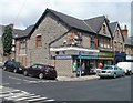
1
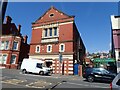
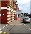
1 Broad Street, Barry
Barry Masonic Hall, built in 1905. Above the front door is a blue plaque, the very first Blue Plaque on a Masonic Centre in South Wales. It states "Freemasons have held meetings in Barry since 1890"
Image: © Eirian Evans
Taken: 23 Jun 2021
0.01 miles
2
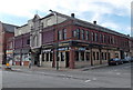
The Sir Samuel Romilly, Barry
Wetherspoon pub on the corner of Broad Street and Market Street. The pub opened in March 2009.
Sir Samuel Romilly (1757-1818) was a British legal reformer. He doesn't appear to have had any direct connection with Barry, which was only a hamlet with fewer than 100 inhabitants during his lifetime. However, the land-owning Romilly family was closely involved with the development of Barry in the second half of the 19th century. Sir Samuel's son John was raised to the peerage as Baron Romilly of Barry in 1866.
Image: © Jaggery
Taken: 17 Mar 2013
0.01 miles
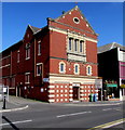
3
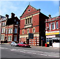
Barry Masonic Hall
Viewed across Broad Street. The hall can be hired for wedding receptions, dances,
meetings and private parties. Peppy's Pizzeria and Best Kebab House are on the right.
Image: © Jaggery
Taken: 18 Aug 2016
0.01 miles
4
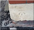
Ordnance Survey Cut Mark
This OS cut mark can be found on the Masonic Hall. It marks a point 16.913m above mean sea level.
Image: © Adrian Dust
Taken: 28 Feb 2018
0.01 miles
5
Shopping areas directions sign, Broad Street, Barry
Outside the Masonic Hall. http://www.geograph.org.uk/photo/5079889
Image: © Jaggery
Taken: 18 Aug 2016
0.01 miles
6
Barry Masonic Hall, Broad Street, Barry
The blue plaque https://www.geograph.org.uk/photo/6261953 above the entrance records that freemasons have held meetings in Barry since 1890.
Image: © Jaggery
Taken: 8 Sep 2019
0.01 miles
7
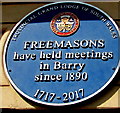
Freemasons blue plaque, Broad Street, Barry
The Provincial Grand Lodge of South Wales blue plaque on Barry Masonic Hall https://www.geograph.org.uk/photo/6261950 records that freemasons have held meetings in Barry since 1890.
Image: © Jaggery
Taken: 8 Sep 2019
0.01 miles
8
The Sir Samuel Romilly, Broad Street
Named for Samuel Romilly, who purchased the Barry and Porthkerry estates (1950 acres) in 1812. This became the modern Barry
Image: © Eirian Evans
Taken: 23 Jun 2021
0.02 miles
9
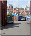
B.W.Autos in Barry
Garage set back 40 metres from the A4055 Broad Street.
Image: © Jaggery
Taken: 18 Aug 2016
0.02 miles
10
Smolanny's, Barry
Smolanny's, at 1 High Street, opened in 2005. The business sells items for babies and children, including clothing and footwear, books, toys, prams and pram accessories.
Image: © Jaggery
Taken: 9 Jul 2011
0.02 miles