
IMAGES TAKEN NEAR TO
BARRY, CF62 6RT
Introduction
This page details the photographs taken nearby to CF62 6RT by members of the Geograph project.
The Geograph project started in 2005 with the aim of publishing, organising and preserving representative images for every square kilometre of Great Britain, Ireland and the Isle of Man.

There are currently over 7.5m images from over14,400 individuals and you can help contribute to the project by visiting https://www.geograph.org.uk
Image Map
Images are licensed for reuse under creativecommons.org/licenses/by-sa/2.0
Notes
- Clicking on the map will re-center to the selected point.
- The higher the marker number, the further away the image location is from the centre of the postcode.
Image Listing (146 Images Found)
Images are licensed for reuse under creativecommons.org/licenses/by-sa/2.0
Image
Details
Distance
1
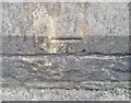
Ordnance Survey Cut Mark
This OS cut mark can be found on the north face of the Sea Scout Hall. It marks a point 36.652m above mean sea level.
Image: © Adrian Dust
Taken: 28 Feb 2018
0.03 miles
2
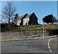
6th Barry Sea Scouts St Nicholas Scout Hall, Barry
Viewed across Romilly Park Road. The former St Nicholas church has been a sea scout hall since the 1950s. The sea scouts website states that the old St Nicholas Church had been the original parish church, dating from the 13th century. It was rebuilt in 1873-76 just before the building of Barry Docks.
With the explosion in the population of Barry between 1884 to 1900, the church was totally inadequate to accommodate the congregation. The completion in 1908 of a new church, All Saints, made St Nicholas redundant. It was used as a Sunday School until the 1930s, but was then disused.
The weather, time and vandals took their toll. All the windows were bricked up in the 1940s. The sea scouts skipper Mr Jack Evans asked the Parochial Church Council whether the group could use the old church. After initial misgivings, the council saw the sense in utilising the old church before it became a complete ruin, and that its use by the youth of the parish would be a good alternative. The Parochial Church Council agreed to lease the building at a peppercorn rent of £1 per annum, on condition that the sea scout group repaired it. After the building was deconsecrated, much renovation and conversion work was done before the building was fit for use as a sea scout hall.
Image: © Jaggery
Taken: 5 Mar 2013
0.03 miles
3
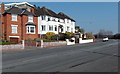
Houses near the NE end of Romilly Park Road, Barry
Looking towards Park Avenue.
Image: © Jaggery
Taken: 5 Mar 2013
0.04 miles
4
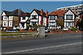
Romilly Park Road houses, Barry
Most of Romilly Park Road forms a loop around the perimeter of Romilly Park.
This part of the road is near the SE edge of the park.
Image: © Jaggery
Taken: 5 Mar 2013
0.04 miles
5
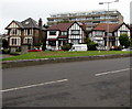
Romilly Park Road houses, Barry
Viewed across two grass triangles.
Image: © Jaggery
Taken: 11 Sep 2019
0.04 miles
6
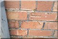
Ordnance Survey Cut Mark
This OS cut mark can be found on No7 The Grove. It marks a point 31.193m above mean sea level.
Image: © Adrian Dust
Taken: 28 Feb 2018
0.04 miles
7
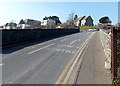
One-way system across St Nicholas Road railway bridge, Barry
Traffic flow is away from the camera along this section of road which crosses over
the Vale of Glamorgan Line railway from Barry to Bridgend via Rhoose and Llantwit Major.
The former St Nicholas church, http://www.geograph.org.uk/photo/3775304 a sea scout hall since the mid 1950s, is in the background.
Image: © Jaggery
Taken: 5 Mar 2013
0.05 miles
8
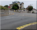
Junction at the northeast end of Romilly Park Road, Barry
A red STOP sign faces Romilly Park Road at the St Nicholas Road junction.
Image: © Jaggery
Taken: 11 Sep 2019
0.05 miles
9
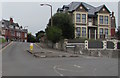
Junction of St Nicholas Road and Park Avenue, Barry
St Nicholas Road is on the left.
Image: © Jaggery
Taken: 11 Sep 2019
0.06 miles
10
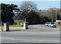
Stone pillars at the SE entrance to Romilly Park, Barry
Viewed across Romilly Park Road.
Image: © Jaggery
Taken: 5 Mar 2013
0.06 miles