IMAGES TAKEN NEAR TO
Romilly Park Road, BARRY, CF62 6RQ
Introduction
This page details the photographs taken nearby to Romilly Park Road, CF62 6RQ by members of the Geograph project.
The Geograph project started in 2005 with the aim of publishing, organising and preserving representative images for every square kilometre of Great Britain, Ireland and the Isle of Man.

There are currently over 7.5m images from over14,400 individuals and you can help contribute to the project by visiting https://www.geograph.org.uk
Image Map
Images are licensed for reuse under creativecommons.org/licenses/by-sa/2.0
Notes
- Clicking on the map will re-center to the selected point.
- The higher the marker number, the further away the image location is from the centre of the postcode.
Image Listing (162 Images Found)
Images are licensed for reuse under creativecommons.org/licenses/by-sa/2.0
Image
Details
Distance
1
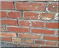
Ordnance Survey Cut Mark
This OS cut mark can be found on the wall of No32 Romilly Park Road. It marks a point 37.039m above mean sea level.
Image: © Adrian Dust
Taken: 28 Feb 2018
0.02 miles
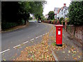
2
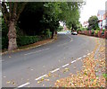
Up Romilly Park Road, Barry
Romilly Park Road ascends to the WNW away from the corner of Romilly Avenue.
Dead leaves are on both sides of the road on September 11th 2019.
Image: © Jaggery
Taken: 11 Sep 2019
0.03 miles
3
Old Village Road west of Romilly Avenue, Barry
The Romilly Avenue junction is on the left.
Image: © Jaggery
Taken: 11 Sep 2019
0.04 miles
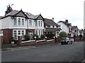
4
Semis at the top of Romilly Avenue, Barry
Semi-detached houses at the northern end of Romilly Avenue viewed from Old Village Road.
Image: © Jaggery
Taken: 11 Sep 2019
0.04 miles
5
King George V pillarbox, Romilly Park Road, Barry
Located near the corner of Romilly Avenue. The GR on the box is short for Georgius Rex,
Latin for King George, in this case King George V who reigned from May 1910-January 1936.
Image: © Jaggery
Taken: 11 Sep 2019
0.05 miles
6
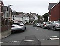
Car-lined Romilly Avenue, Barry
Romilly Avenue descends from Old Village Road.
Image: © Jaggery
Taken: 11 Sep 2019
0.06 miles
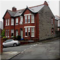
7
Romilly Avenue houses, Barry
On the approach to the Romilly Park Road junction.
Image: © Jaggery
Taken: 11 Sep 2019
0.06 miles
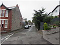
8
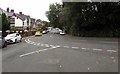
Junction of Romilly Avenue and Romilly Park Road, Barry
Viewed from the southern end of Romilly Avenue.
Image: © Jaggery
Taken: 11 Sep 2019
0.07 miles
9
Stone and brick building on a suburban corner, Barry
Stone building with brick edgings on the corner of Old Village Road and Yew Tree Court.
Image: © Jaggery
Taken: 11 Sep 2019
0.07 miles
10
Yew Tree Court this way, Barry
On the right, the black arrow on the sign on the corner of Old Village Road points ahead.
Image: © Jaggery
Taken: 11 Sep 2019
0.07 miles