IMAGES TAKEN NEAR TO
Phyllis Street, BARRY, CF62 5UT
Introduction
This page details the photographs taken nearby to Phyllis Street, CF62 5UT by members of the Geograph project.
The Geograph project started in 2005 with the aim of publishing, organising and preserving representative images for every square kilometre of Great Britain, Ireland and the Isle of Man.

There are currently over 7.5m images from over14,400 individuals and you can help contribute to the project by visiting https://www.geograph.org.uk
Image Map
Images are licensed for reuse under creativecommons.org/licenses/by-sa/2.0
Notes
- Clicking on the map will re-center to the selected point.
- The higher the marker number, the further away the image location is from the centre of the postcode.
Image Listing (98 Images Found)
Images are licensed for reuse under creativecommons.org/licenses/by-sa/2.0
Image
Details
Distance
1
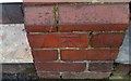
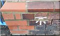
Ordnance Survey Cut Mark
This OS cut mark can be found on No33 Clive Road. It marks a point 19.696m above mean sea level.
Image: © Adrian Dust
Taken: 11 Mar 2018
0.03 miles
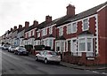
2
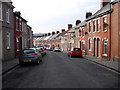
Phyllis St, Barry Island
Looking west from the junction with Ivor St.
Image: © John Lord
Taken: 22 Mar 2011
0.04 miles
3
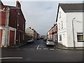
Eastern end of Phyllis Street, Barry Island
Viewed from Clive Place. Phyllis Street was named after a daughter of the Earl of Plymouth,
who was a major landowner in Barry at the end of the 19th and start of the 20th century.
Image: © Jaggery
Taken: 30 Dec 2012
0.06 miles
4
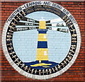
Badge painted on the wall of Barry Island Primary School and Nursery
The badge is on the Archer Road side of the building. http://www.geograph.org.uk/photo/3277403
Image: © Jaggery
Taken: 30 Dec 2012
0.06 miles
5
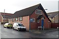
St Baruc's Church, Barry Island
Church in Wales church on the corner of Phyllis Street and Archer Road.
Image: © Jaggery
Taken: 30 Dec 2012
0.07 miles
6

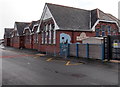
Corner view of Barry Island Primary School and Nursery
Located on the corner of Clive Road (on the right) and Archer Road.
http://www.geograph.org.uk/photo/3277404 to a view of the badge painted on the wall.
Image: © Jaggery
Taken: 30 Dec 2012
0.07 miles
7
Ordnance Survey Cut Mark
This OS cut mark can be found on the north face of the school, Clive Road. It marks a point 17.550m above mean sea level.
Image: © Adrian Dust
Taken: 11 Mar 2018
0.07 miles
8
West side of Barry Island Primary School and Nursery
This is the Clive Road side of the school which occupies a site on the corner of Archer Road.
Image: © Jaggery
Taken: 30 Dec 2012
0.07 miles
9
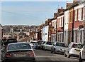
Phyllis Street, Barry Island
One of many terraced streets on Barry Island and in Barry itself.
Image: © Mick Lobb
Taken: 19 Nov 2008
0.09 miles
10
Clive Road east of Ivor Street, Barry Island
Clive Road houses are all on one side of the street.
On the opposite side is a boundary fence at the edge of Barry docks.
Image: © Jaggery
Taken: 30 Dec 2012
0.10 miles