IMAGES TAKEN NEAR TO
Marquis Close, BARRY, CF62 5UE
Introduction
This page details the photographs taken nearby to Marquis Close, CF62 5UE by members of the Geograph project.
The Geograph project started in 2005 with the aim of publishing, organising and preserving representative images for every square kilometre of Great Britain, Ireland and the Isle of Man.

There are currently over 7.5m images from over14,400 individuals and you can help contribute to the project by visiting https://www.geograph.org.uk
Image Map
Images are licensed for reuse under creativecommons.org/licenses/by-sa/2.0
Notes
- Clicking on the map will re-center to the selected point.
- The higher the marker number, the further away the image location is from the centre of the postcode.
Image Listing (119 Images Found)
Images are licensed for reuse under creativecommons.org/licenses/by-sa/2.0
Image
Details
Distance
1
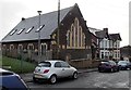
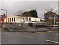
Former Barry Island Presbyterian Church
Viewed across Earl Crescent. Now converted to residential use,
this used to be Barry Island Presbyterian Church, built in 1904.
Image: © Jaggery
Taken: 30 Dec 2012
0.03 miles
2
NE end of Earl Crescent, Barry Island
Earl Crescent is a cul-de-sac on the NE side of Friars Road.
Image: © Jaggery
Taken: 30 Dec 2012
0.04 miles
3
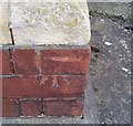
Ordnance Survey Cut Mark
This OS cut mark can be found on No32 Redbrink Crescent. It marks a point 38.869m above mean sea level.
Image: © Adrian Dust
Taken: 11 Mar 2018
0.04 miles
4
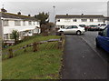
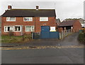
Redbrink Crescent, Barry
Viewed from the corner of Dyfrig Street. Marquis Close is on the left.
Image: © Jaggery
Taken: 30 Dec 2012
0.05 miles
5
Corner of Friars Road and Earl Crescent, Barry Island
The large building on the left is Barry Island Community Centre.
Image: © Jaggery
Taken: 30 Dec 2012
0.06 miles
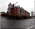
6
Barry Island Coastguard Rescue Station
Viewed across Redbrink Crescent.
The HM Coastguard building on the right is part of MCA (Maritime and Coastguard Agency). A notice on the wall states that it is a criminal offence to leave flares/pyrotechnics at this property.
Image: © Jaggery
Taken: 30 Dec 2012
0.06 miles

8
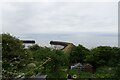
Sea wall from Redbrink Crescent
Looking down towards the entrance into Barry Docks.
Image: © DS Pugh
Taken: 24 Jun 2024
0.07 miles
9
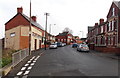
Western end of Redbrink Crescent, Barry Island
Viewed from the edge of The Triangle. http://www.geograph.org.uk/photo/3278254 Redbrink Crescent takes its make from Redbrink Point,
a nearby coastal area where the cliffs have strata of reddish rocks.
Image: © Jaggery
Taken: 30 Dec 2012
0.07 miles
10
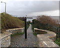
Path to Jackson's Bay, Barry
The path descends from Redbrink Crescent.
Image: © Jaggery
Taken: 30 Dec 2012
0.07 miles