1
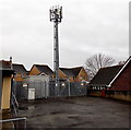
Telecoms mast near St John Methodist Church, Barry
Set back from the south side of Breaksea Drive, near this http://www.geograph.org.uk/photo/3743897 church.
Image: © Jaggery
Taken: 30 Dec 2012
0.02 miles
2
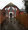
St John Methodist Church, Barry Island
Set back 40 metres from the south side of Breaksea Drive.
The name of the church is St John not St John's. The church, which opened in 1902, was originally named Barry Island Wesleyan Methodist Church. During the First World War, it was converted for use as a hospital, staffed by members of St John Ambulance. Its use as a hospital ended in December 1919, whereupon the building was handed back to the church members. In tribute to the war work, the members renamed the church St John Methodist Church.
Image: © Jaggery
Taken: 30 Dec 2012
0.02 miles
3
Front view of St John Methodist Church, Barry Island
See http://www.geograph.org.uk/photo/3743897 for a side view and some details.
Image: © Jaggery
Taken: 30 Dec 2012
0.02 miles
4
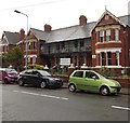
Breaksea Court, Barry Island
Flats on the corner of Breaksea Drive and Friars Road.
Image: © Jaggery
Taken: 30 Dec 2012
0.02 miles
5
Ordnance Survey Cut Mark
This OS cut mark can be found on St John's Church. It marks a point 33.354m above mean sea level.
Image: © Adrian Dust
Taken: 11 Mar 2018
0.02 miles
6
Towards the tunnel between Barry Island and Barry Pier
Image: © Gareth James
Taken: 25 Aug 2007
0.03 miles
7
Barry Island
Looking over Whitmore Bay towards the docks
Image: © M J Richardson
Taken: 4 Oct 2010
0.03 miles
8
Blocked off western portal to the tunnel to the former Barry Pier railway station
The c250 metre long tunnel formerly led to Barry Pier railway station, which closed in the 1970s.
The station was about 750 metres east of the present-day end of the line at Barry Island station.
Image: © Jaggery
Taken: 30 Dec 2012
0.03 miles
9
Breaksea Drive, Barry
Image: © Colin Pyle
Taken: 20 Apr 2018
0.03 miles
10
Island View residential care home, Barry Island
Viewed across Friars Road. Island View was formerly named Kenilworth House.
Image: © Jaggery
Taken: 30 Dec 2012
0.05 miles


