1
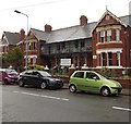
Breaksea Court, Barry Island
Flats on the corner of Breaksea Drive and Friars Road.
Image: © Jaggery
Taken: 30 Dec 2012
0.01 miles
2
Ordnance Survey Cut Mark
This OS cut mark can be found on St John's Church. It marks a point 33.354m above mean sea level.
Image: © Adrian Dust
Taken: 11 Mar 2018
0.03 miles
3
Barry Island Coastguard Rescue Station
Viewed across Redbrink Crescent.
The HM Coastguard building on the right is part of MCA (Maritime and Coastguard Agency). A notice on the wall states that it is a criminal offence to leave flares/pyrotechnics at this property.
Image: © Jaggery
Taken: 30 Dec 2012
0.03 miles
4
Island View residential care home, Barry Island
Viewed across Friars Road. Island View was formerly named Kenilworth House.
Image: © Jaggery
Taken: 30 Dec 2012
0.03 miles
5
St John Methodist Church, Barry Island
Set back 40 metres from the south side of Breaksea Drive.
The name of the church is St John not St John's. The church, which opened in 1902, was originally named Barry Island Wesleyan Methodist Church. During the First World War, it was converted for use as a hospital, staffed by members of St John Ambulance. Its use as a hospital ended in December 1919, whereupon the building was handed back to the church members. In tribute to the war work, the members renamed the church St John Methodist Church.
Image: © Jaggery
Taken: 30 Dec 2012
0.03 miles
6
Remains of St Baruch's Chapel
Bases of the walls of a small medieval chapel, enclosed in railings, on Friar's Road overlooking the Bristol Channel.
Image: © M J Roscoe
Taken: 6 Sep 2021
0.04 miles
7
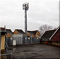
Telecoms mast near St John Methodist Church, Barry
Set back from the south side of Breaksea Drive, near this http://www.geograph.org.uk/photo/3743897 church.
Image: © Jaggery
Taken: 30 Dec 2012
0.04 miles
8
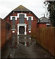
Front view of St John Methodist Church, Barry Island
See http://www.geograph.org.uk/photo/3743897 for a side view and some details.
Image: © Jaggery
Taken: 30 Dec 2012
0.04 miles
9
Corner of Friars Road and Earl Crescent, Barry Island
The large building on the left is Barry Island Community Centre.
Image: © Jaggery
Taken: 30 Dec 2012
0.04 miles
10
Remains of St Baruch's chapel, Barry Island
Located in a fenced compound on the east side of Friars Road, these are the ruins of a small pilgrimage chapel of medieval (c12th-14th century) origin. Said to be the site of the grave of a Celtic saint, perhaps an itinerant Irishman, Barruc alias Finbar, the patron saint of Cork. Excavations have shown that there was an older burial ground on this site. The chapel was abandoned in the early 16th century and the ruins were gradually engulfed by sand dunes.
Image: © Jaggery
Taken: 30 Dec 2012
0.04 miles


