IMAGES TAKEN NEAR TO
Ffordd Y Dociau, BARRY, CF62 5DX
Introduction
This page details the photographs taken nearby to Ffordd Y Dociau, CF62 5DX by members of the Geograph project.
The Geograph project started in 2005 with the aim of publishing, organising and preserving representative images for every square kilometre of Great Britain, Ireland and the Isle of Man.

There are currently over 7.5m images from over14,400 individuals and you can help contribute to the project by visiting https://www.geograph.org.uk
Image Map (64 Images)


Leaflet Map data © OpenStreetMap
Images are licensed for reuse under creativecommons.org/licenses/by-sa/2.0
Notes
- Clicking on the map will re-center to the selected point.
- The higher the marker number, the further away the image location is from the centre of the postcode.
Image Listing (64 Images Found)
Images are licensed for reuse under creativecommons.org/licenses/by-sa/2.0
Image
Details
Distance
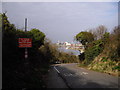
1
Dock Road, Barry Island
Dock Road climbs away from the docks area, towards The Triangle. http://www.geograph.org.uk/photo/3278254
Image: © Jaggery
Taken: 30 Dec 2012
0.06 miles
2
An entrance to Barry Docks
Barry Docks, or the port of Barry, is located nine miles west of Cardiff. Built in the 1880s to export coal, Barry was by 1913 the largest coal exporting port in the world. In the early 21st century, the port is a key facility for the region's chemical industry, handling liquid bulks for major companies including Dow Corning. Barry also handles steel, scrap metal, containers, dry bulks, coal and aggregates.
Image: © Jaggery
Taken: 30 Dec 2012
0.06 miles
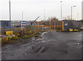
3

Docks Entrance
Secured entrance to Barry Docks.
Image: © Alan Hughes
Taken: 8 Mar 2017
0.06 miles
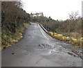
4

20mph speed limit on Dock Road, Barry Island
Dock Road descends from The Triangle http://www.geograph.org.uk/photo/3278254 past a flight of steps on the right. http://www.geograph.org.uk/photo/3278330 The notice states that there is no access ahead to the main port estate. The Cadoxton entrance is open 24 hours.
Image: © Jaggery
Taken: 30 Dec 2012
0.07 miles
5
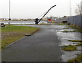
Crane in Barry Docks
Viewed through the perimeter fence here. http://www.geograph.org.uk/photo/3326718
Image: © Jaggery
Taken: 30 Dec 2012
0.07 miles
6
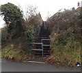
Flight of steps, Dock Road, Barry Island
The steps ascend from Dock Road to Dyfrig Street.
Image: © Jaggery
Taken: 30 Dec 2012
0.08 miles
7

Dock Road, Barry Island
Dock Road descends past flats in The Triangle. http://www.geograph.org.uk/photo/3278254
Signs show that this is the way to the Pilot Station and the RNLI premises (Lifeboat Station).
Image: © Jaggery
Taken: 30 Dec 2012
0.08 miles
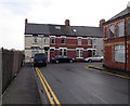
8

Clive Place, Barry Island
Viewed from the corner of Phyllis Street looking along Clive Place towards the corner of Clive Road.
Image: © Jaggery
Taken: 30 Dec 2012
0.08 miles
9
Northern end of Clive Place, Barry Island
Viewed along Clive Road. The cars are parked in Clive Place.
The fence is at the perimeter of Barry docks.
Image: © Jaggery
Taken: 30 Dec 2012
0.08 miles