1
Susan on Barry Island Viaduct
Sentinel 0-4-0 Susan, with Diesel Multiple Unit 'Iris II' in tow, crosses Barry Island Viaduct with a Santa Special working on the Barry Tourist Railway.
Image: © Gareth James
Taken: 16 Dec 2018
0.02 miles
2
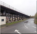
Railway viaduct entrance to Harbour Road car park, Barry Island
Car drivers enter Harbour Road car park here, under the viaduct carrying the railway between Barry Island station and Barry station. Road markings direct coaches right to the coach park.
Image: © Jaggery
Taken: 30 Dec 2012
0.02 miles
3
Barry Island Viaduct
The road and railway viaducts, looking from Barry Island. On the right, locomotive 73118 of the Barry Tourist Railway heads back from the island.
Image: © Gareth James
Taken: 3 Sep 2011
0.03 miles
4
Barry Tourist Railway
Visiting locomotive, Met tank No. 1, crosses the causeway viaduct on the approach to Barry Island station.
Image: © Gareth James
Taken: 31 Aug 2014
0.03 miles
5
Welcome to Barry Island
Barry Island was an island until the late 1880s when it was joined to the mainland by Old Harbour Road and the Barry Island railway as part of the Barry Docks development scheme. The train continues to bring tourists to the popular holiday resort.
Image: © Alan Hughes
Taken: 30 Aug 2023
0.03 miles
6
Cars on the left, coaches in the middle, Barry Island
Road markings direct vehicles to the appropriate part of Harbour Road car and coach park.
Image: © Jaggery
Taken: 30 Dec 2012
0.03 miles
7
Across the viaduct to Barry Island station
An Arriva Trains Wales service heads towards the end of the line at Barry Island station. The return journey will be to Merthyr Tydfil, via Cardiff and Pontypridd. The fleet number in view is 150285.
Image: © Jaggery
Taken: 5 Mar 2013
0.03 miles
8
Public toilets, Harbour Road car park, Barry Island
The toilets are near the entrance on the north side of the large car park. http://www.geograph.org.uk/photo/3276473
The viaduct on the right carries the railway between Barry Island station and Barry station.
The red and yellow arms of a semaphore signal http://www.geograph.org.uk/photo/3835282 can be seen behind the toilet roof.
Image: © Jaggery
Taken: 30 Dec 2012
0.03 miles
9
Railway viaduct, Barry Island
Viewed from the entrance http://www.geograph.org.uk/photo/3276428 to Harbour Road car park. The viaduct carries the railway between Barry Island station and Barry station. The road leads to the coach parking area.
Image: © Jaggery
Taken: 30 Dec 2012
0.04 miles
10
Left or right for the beach, Barry Island
The sign points left for steps up to the road to the beach, or right to another route to the beach.
The location is the NE corner of Harbour Road car park.
The viaduct carries the railway between Barry station and Barry Island station.
Image: © Jaggery
Taken: 30 Dec 2012
0.04 miles


