IMAGES TAKEN NEAR TO
Lougher Place, BARRY, CF62 4PW
Introduction
This page details the photographs taken nearby to Lougher Place, CF62 4PW by members of the Geograph project.
The Geograph project started in 2005 with the aim of publishing, organising and preserving representative images for every square kilometre of Great Britain, Ireland and the Isle of Man.

There are currently over 7.5m images from over14,400 individuals and you can help contribute to the project by visiting https://www.geograph.org.uk
Image Map (Loading...)


Getting Data...Please wait
Leaflet Map data © OpenStreetMap
Images are licensed for reuse under creativecommons.org/licenses/by-sa/2.0
Notes
- Clicking on the map will re-center to the selected point.
- The higher the marker number, the further away the image location is from the centre of the postcode.
Image Listing (113 Images Found)
Images are licensed for reuse under creativecommons.org/licenses/by-sa/2.0
Image
Details
Distance
1
Lougher Place, St Athan
Ahead for Berkrolles Avenue. A path to Chapel Close is behind the camera.
Image: © Jaggery
Taken: 19 Sep 2019
0.06 miles
2
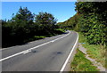
Bend in the B4265 at the southern edge of St Athan
Ahead for Eglwys Brewis, Boverton and Llantwit Major.
Image: © Jaggery
Taken: 19 Sep 2019
0.09 miles
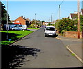
3

Van, hedges and houses, Lougher Place, St Athan
On the north side of Lougher Place near its eastern end.
Image: © Jaggery
Taken: 19 Sep 2019
0.09 miles
4

Towards Pant-y-celyn Place, St Athan
Viewed along a side road from Lougher Place.
Image: © Jaggery
Taken: 19 Sep 2019
0.12 miles
5
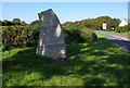
Glamorgan Heritage Coast sign at the southern edge of St Athan
On grass on the south side of the B4265 viewed in September 2019.
A May 2016 Google Street View showed no sign here.
Image: © Jaggery
Taken: 19 Sep 2019
0.12 miles
6
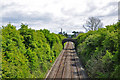
Railway track south of St Athan
The bridge provides access between two fields on opposite sides of the track and for a public footpath. In the distance stands the stack at Aberthaw cement works.
Image: © Mick Lobb
Taken: 3 May 2009
0.13 miles
7
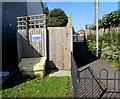
Chapel Close Sewage Pumping Station, St Athan
Welsh Water Asset number 72985 at the western end of Chapel Close.
The path leads to Lougher Place.
Image: © Jaggery
Taken: 19 Sep 2019
0.14 miles
8
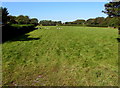
Distant sheep in a field near Gileston
On the west side of Gileston Road, south of St Athan, north of Gileston.
Image: © Jaggery
Taken: 19 Sep 2019
0.14 miles
10

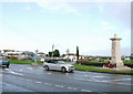
Co-op, St Athan
Set back from the west side of Gileston Road viewed in September 2019.
A May 2016 Google Street View shows a derelict former car sales business here.
Image: © Jaggery
Taken: 19 Sep 2019
0.15 miles