IMAGES TAKEN NEAR TO
Tathan Crescent, BARRY, CF62 4PE
Introduction
This page details the photographs taken nearby to Tathan Crescent, CF62 4PE by members of the Geograph project.
The Geograph project started in 2005 with the aim of publishing, organising and preserving representative images for every square kilometre of Great Britain, Ireland and the Isle of Man.

There are currently over 7.5m images from over14,400 individuals and you can help contribute to the project by visiting https://www.geograph.org.uk
Image Map
Images are licensed for reuse under creativecommons.org/licenses/by-sa/2.0
Notes
- Clicking on the map will re-center to the selected point.
- The higher the marker number, the further away the image location is from the centre of the postcode.
Image Listing (91 Images Found)
Images are licensed for reuse under creativecommons.org/licenses/by-sa/2.0
Image
Details
Distance
1
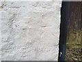
Ordnance Survey Cut Mark
This OS cut mark can be found on The Four Bells. It marks a point 30.498m above mean sea level.
Image: © Adrian Dust
Taken: 11 Mar 2018
0.06 miles
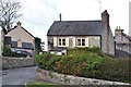
4
Tathan Crescent, St Athan
On the east side of Cowbridge Road/Rectory Road.
Signs indicate No motor vehicles except for access.
Maps show that Cowbridge Road is north (left)
of this junction - Rectory Road is south.
Image: © Jaggery
Taken: 17 Sep 2019
0.07 miles
6

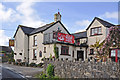
View along small lane at Saint Athan
The Four Bells pub http://www.geograph.org.uk/photo/1284239 is just behind the photographer.
Image: © Nick Smith
Taken: 22 Apr 2011
0.07 miles
7
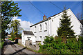
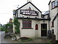
The Old Chapel, Castleton Road near St Athan
Image: © Mick Lobb
Taken: 3 May 2009
0.08 miles
8
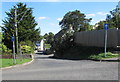
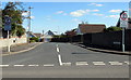
St John's Hill, St Athan
From the east side of Cowbridge Road, one-way St John's Hill leads to Rock Road.
Image: © Jaggery
Taken: 17 Sep 2019
0.08 miles
9
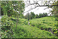
Un-named tributary of the River Thaw, Castleton - St Athan
Image: © Mick Lobb
Taken: 3 May 2009
0.08 miles
10
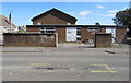
St Athan Exchange
Set back from the east side of Rectory Road, St Athan Exchange provides broadband and telephone services for about 1,700 residential premises and 40 non-residential premises. The Exchange identifier is SWXTP.
Image: © Jaggery
Taken: 17 Sep 2019
0.09 miles