IMAGES TAKEN NEAR TO
Beggars Pound, BARRY, CF62 4PB
Introduction
This page details the photographs taken nearby to Beggars Pound, CF62 4PB by members of the Geograph project.
The Geograph project started in 2005 with the aim of publishing, organising and preserving representative images for every square kilometre of Great Britain, Ireland and the Isle of Man.

There are currently over 7.5m images from over14,400 individuals and you can help contribute to the project by visiting https://www.geograph.org.uk
Image Map
Images are licensed for reuse under creativecommons.org/licenses/by-sa/2.0
Notes
- Clicking on the map will re-center to the selected point.
- The higher the marker number, the further away the image location is from the centre of the postcode.
Image Listing (89 Images Found)
Images are licensed for reuse under creativecommons.org/licenses/by-sa/2.0
Image
Details
Distance
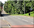
2
St John's Hill, St Athan
From the east side of Cowbridge Road, one-way St John's Hill leads to Rock Road.
Image: © Jaggery
Taken: 17 Sep 2019
0.04 miles
3
The Old Chapel, Castleton Road near St Athan
Image: © Mick Lobb
Taken: 3 May 2009
0.05 miles
4
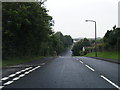
Cowbridge Road - St Athan
There is a considerable dip in the road at this point and was at one time, perhaps still is,a notorious speeding point as drivers accelerated down one slope to ease their passage up the other. Needless to say, many paid the price in speeding fines!
Image: © Mick Lobb
Taken: 3 May 2009
0.06 miles
6
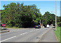
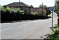
Leafy part of Cowbridge Road, St Athan
Looking to the north away from the centre of the village.
Image: © Jaggery
Taken: 17 Sep 2019
0.07 miles
7
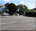
Junction of Cowbridge Road and Rock Road, St Athan
The cars are in Rock Road.
Image: © Jaggery
Taken: 17 Sep 2019
0.08 miles
8
Cowbridge Road School/Ysgol direction sign, St Athan
The English/Welsh sign points left towards Rock Road which leads to St Athan Primary School.
Image: © Jaggery
Taken: 13 Sep 2019
0.09 miles
9
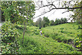
Un-named tributary of the River Thaw, Castleton - St Athan
Image: © Mick Lobb
Taken: 3 May 2009
0.09 miles
10
School/Ysgol direction sign, Cowbridge Road, St Athan
English/Welsh sign pointing left to Rock Road which leads to St Athan Primary School.
Image: © Jaggery
Taken: 17 Sep 2019
0.09 miles