IMAGES TAKEN NEAR TO
Mallory Close, BARRY, CF62 4JJ
Introduction
This page details the photographs taken nearby to Mallory Close, CF62 4JJ by members of the Geograph project.
The Geograph project started in 2005 with the aim of publishing, organising and preserving representative images for every square kilometre of Great Britain, Ireland and the Isle of Man.

There are currently over 7.5m images from over14,400 individuals and you can help contribute to the project by visiting https://www.geograph.org.uk
Image Map (Loading...)


Getting Data...Please wait
Leaflet Map data © OpenStreetMap
Images are licensed for reuse under creativecommons.org/licenses/by-sa/2.0
Notes
- Clicking on the map will re-center to the selected point.
- The higher the marker number, the further away the image location is from the centre of the postcode.
Image Listing (39 Images Found)
Images are licensed for reuse under creativecommons.org/licenses/by-sa/2.0
Image
Details
Distance
1
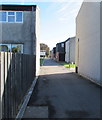
Livingstone Way, St Athan
From the east side of Cowbridge Road.
Image: © Jaggery
Taken: 13 Sep 2019
0.05 miles
2
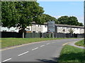
Former Married Quarters, St Athan
Formerly military MQ's the houses on this estate, among others in the vicinity of the RAF base, were sold to a private company for refurbishment before being sold on into private ownership.
Image: © Mick Lobb
Taken: 23 Jun 2008
0.06 miles
3
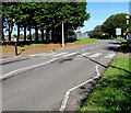
Zebra crossing, Cowbridge Road, Eglwys Brewis
This part of Eglwys Brewis is near the St Athan boundary sign behind the camera.
Image: © Jaggery
Taken: 13 Sep 2019
0.06 miles
4
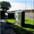
Graffiti-daubed cabinet alongside Cowbridge Road, St Athan
One of two telecoms cabinets near the corner of Livingstone Way.
Image: © Jaggery
Taken: 13 Sep 2019
0.07 miles
5
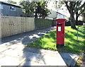
Queen Elizabeth II pillarbox, Cowbridge Road, St Athan
Behind the bus shelter on the left here. https://www.geograph.org.uk/photo/6284049
Image: © Jaggery
Taken: 13 Sep 2019
0.07 miles
6
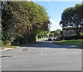
Flemingston Road, Eglwys Brewis
Looking to the NE along Flemingston Road from Cowbridge Road.
A sign near the camera shows three-quarters of a mile to Flemingston.
Image: © Jaggery
Taken: 13 Sep 2019
0.07 miles
7
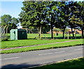
Green cabinet set back from Cowbridge Road, Eglwys Brewis
The cabinet is a Western Power Distribution electricity substation.
Its identifier is BROADWAY SWITCHING SITE S/S 56 - 4329
Image: © Jaggery
Taken: 13 Sep 2019
0.08 miles
8
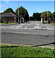
Exit from MOD St Athan into Cowbridge Road
No entry to the Ministry of Defence site here - the East Gate entrance is nearby.
MOD St Athan was formerly known as RAF St Athan.
Image: © Jaggery
Taken: 13 Sep 2019
0.09 miles
9
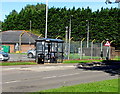
Cowbridge Road bus stop and shelter, St Athan
On bus route 303 from Barry to Bridgend. In September 2019 the route is operated by NAT Group.
Image: © Jaggery
Taken: 13 Sep 2019
0.09 miles
10
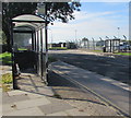
Two bus shelters, Cowbridge Road, St Athan
The shelter on the left is alongside a stop on bus route 303 to Barry.
The shelter on the right is alongside a stop on bus route 303 to Bridgend.
In September 2019 route 303 is operated by NAT Group.
Image: © Jaggery
Taken: 13 Sep 2019
0.09 miles