IMAGES TAKEN NEAR TO
Glyndwr Avenue, BARRY, CF62 4FZ
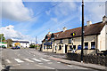
Introduction
This page details the photographs taken nearby to Glyndwr Avenue, CF62 4FZ by members of the Geograph project.
The Geograph project started in 2005 with the aim of publishing, organising and preserving representative images for every square kilometre of Great Britain, Ireland and the Isle of Man.

There are currently over 7.5m images from over14,400 individuals and you can help contribute to the project by visiting https://www.geograph.org.uk
Image Map
Images are licensed for reuse under creativecommons.org/licenses/by-sa/2.0
Notes
- Clicking on the map will re-center to the selected point.
- The higher the marker number, the further away the image location is from the centre of the postcode.
Image Listing (116 Images Found)
Images are licensed for reuse under creativecommons.org/licenses/by-sa/2.0
Image
Details
Distance
1
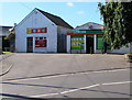
Londis convenience store, St Athan
Set back from the west side of Rectory Road.
Image: © Jaggery
Taken: 17 Sep 2019
0.03 miles
2
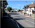
Rectory Road pelican crossing, St Athan
The Three Horseshoes pub is on the right. https://www.geograph.org.uk/photo/6269169
Image: © Jaggery
Taken: 17 Sep 2019
0.03 miles
3
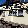
Three Horseshoes nameboard, St Athan
In September 2019, the board on the left here https://www.geograph.org.uk/photo/6269169 shows HAND PULLED ALES & HOME COOKED FOOD.
Image: © Jaggery
Taken: 17 Sep 2019
0.04 miles
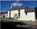
4
The Three Horseshoes, St Athan
Rectory Road pub viewed in September 2019.
The pub was the Kings Cup https://www.geograph.org.uk/photo/1284410 in May 2009.
Image: © Jaggery
Taken: 17 Sep 2019
0.04 miles
5
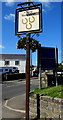
The Three Horseshoes name sign, St Athan
On a Rectory Road post a few metres beyond the left edge of this https://www.geograph.org.uk/photo/6269169 photo.
Image: © Jaggery
Taken: 17 Sep 2019
0.04 miles
6
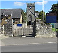
Western entrance gates to St Tathan churchyard, St Athan
Alongside Rectory Road across a path to the church https://www.geograph.org.uk/photo/6269608 in the Church in Wales Diocese of Llandaff.
Image: © Jaggery
Taken: 17 Sep 2019
0.04 miles
7
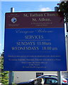
Information board for St Tathan Church, St Athan
On the right here https://www.geograph.org.uk/photo/6269619 in September 2019.
The village name is St Athan in English, Sain Tathan in Welsh.
Image: © Jaggery
Taken: 17 Sep 2019
0.04 miles
8
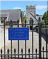
No Dogs or Cycling in this Churchyard, St Athan
The notice is on the gate here. https://www.geograph.org.uk/photo/6269619
Image: © Jaggery
Taken: 17 Sep 2019
0.04 miles
10
Detached house, Rectory Road, St Athan
The Three Horseshoes pub https://www.geograph.org.uk/photo/6269169 is on the left.
Image: © Jaggery
Taken: 17 Sep 2019
0.04 miles