IMAGES TAKEN NEAR TO
Scott Way, BARRY, CF62 4AL
Introduction
This page details the photographs taken nearby to Scott Way, CF62 4AL by members of the Geograph project.
The Geograph project started in 2005 with the aim of publishing, organising and preserving representative images for every square kilometre of Great Britain, Ireland and the Isle of Man.

There are currently over 7.5m images from over14,400 individuals and you can help contribute to the project by visiting https://www.geograph.org.uk
Image Map
Images are licensed for reuse under creativecommons.org/licenses/by-sa/2.0
Notes
- Clicking on the map will re-center to the selected point.
- The higher the marker number, the further away the image location is from the centre of the postcode.
Image Listing (2 Images Found)
Images are licensed for reuse under creativecommons.org/licenses/by-sa/2.0
Image
Details
Distance
2
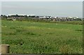
DARA and the 'Twin Peaks', St Athan.
'DARA' refers to the larger white building on the right and 'Twins Peaks' to the roofs of the buildings to the right of picture. All are intended to be used as aircraft servicing facilities but are thought to be under-utilised at the time of the photograph.
Image: © Mick Lobb
Taken: 24 Jun 2008
0.21 miles