1
Kemeys Road, Rhoose
Cul-de-sac on the north side of Fontygary Road.
Image: © Jaggery
Taken: 11 Nov 2019
0.13 miles
2
Rhoose Amateur Boxing Club
On the right, set back from the north side of Fontygary Road.
Rhoose & District Social Club is on the left.
Image: © Jaggery
Taken: 11 Nov 2019
0.14 miles
3
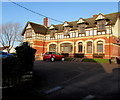
Rhoose & District Social Club
Set back from the north side of Fontygary Road, Rhoose.
Image: © Jaggery
Taken: 11 Nov 2019
0.15 miles
4
The Rhoose and District Social Club, Rhoose
Image: © Mick Lobb
Taken: 25 Nov 2008
0.15 miles
5
Ordnance Survey Cut Mark
This OS cut mark can be found on the east angle of the Club. It marks a point 49.717m above mean sea level.
Image: © Adrian Dust
Taken: 11 Mar 2018
0.15 miles
6
Jubilee Hall, Rhoose
Located on Rhoose Road. Jubilee Hall was built in 1887, the 50th year (golden jubilee) of Queen Victoria’s reign. It was originally a Gospel Mission. In 1938 it was bought by the Wesleyan Methodists. It became a dwelling after its use as a place of worship ended in the 1960s.
Image: © Jaggery
Taken: 11 Jun 2011
0.16 miles
7
Start of the 20 zone, Fontygary Road, Rhoose
The sign on the corner of Kemeys Road is on the approach to Rhws Primary School.
Rhoose is Y Rhws in Welsh. Zone is Parth in Welsh.
Image: © Jaggery
Taken: 11 Nov 2019
0.17 miles
8
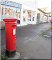
Queen Elizabeth II pillarbox, Fontygary Road, Rhoose
Behind the car on the left here. https://www.geograph.org.uk/photo/6317802
Image: © Jaggery
Taken: 11 Nov 2019
0.17 miles
9
Rhoose Surgery, 19 Fontygary Road, Rhoose
Medical surgery in a single-storey brick building on the south side of Fontygary Road.
Image: © Jaggery
Taken: 11 Nov 2019
0.17 miles
10
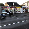
Rhoose Mini Mart, Fontygary Road, Rhoose
In November 2019 the Premier Express Rhoose Mini Mart is flanked by Posh Pawz pet groomer and Barratts Fine Meats butcher's shop.
Image: © Jaggery
Taken: 11 Nov 2019
0.17 miles


