IMAGES TAKEN NEAR TO
Brendon View Close, BARRY, CF62 3ER
Introduction
This page details the photographs taken nearby to Brendon View Close, CF62 3ER by members of the Geograph project.
The Geograph project started in 2005 with the aim of publishing, organising and preserving representative images for every square kilometre of Great Britain, Ireland and the Isle of Man.

There are currently over 7.5m images from over14,400 individuals and you can help contribute to the project by visiting https://www.geograph.org.uk
Image Map
Images are licensed for reuse under creativecommons.org/licenses/by-sa/2.0
Notes
- Clicking on the map will re-center to the selected point.
- The higher the marker number, the further away the image location is from the centre of the postcode.
Image Listing (88 Images Found)
Images are licensed for reuse under creativecommons.org/licenses/by-sa/2.0
Image
Details
Distance
1
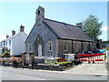
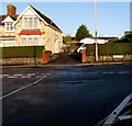
Jubilee Hall, Rhoose
Located on Rhoose Road. Jubilee Hall was built in 1887, the 50th year (golden jubilee) of Queen Victoria’s reign. It was originally a Gospel Mission. In 1938 it was bought by the Wesleyan Methodists. It became a dwelling after its use as a place of worship ended in the 1960s.
Image: © Jaggery
Taken: 11 Jun 2011
0.03 miles
2
Dark green cabinets, Rhoose Road, Rhoose
Two telecoms cabinets viewed from the corner of Station Road.
Image: © Jaggery
Taken: 11 Nov 2019
0.05 miles
3
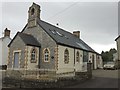
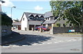
Jubilee Hall, Rhoose
Jubilee Hall, now Chapel House, Rhoose. Built in 1887 to commemorate Queen Victoria's 50th anniversary on the throne.
Image: © Alan Hughes
Taken: 10 Jan 2017
0.05 miles
4
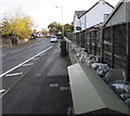
Rhoose Road bus stop and shelter, Rhoose
This stop opposite Station Road is for buses to Barry.
Image: © Jaggery
Taken: 11 Nov 2019
0.05 miles
5
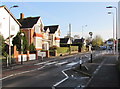
Junction at the northern end of Station Road, Rhoose
Turn left into Fontygary Road or right into Rhoose Road.
Image: © Jaggery
Taken: 11 Nov 2019
0.05 miles
6
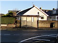
Jackson Close, Rhoose
A detached house occupies the corner of Jackson Close and Rhoose Road.
Image: © Jaggery
Taken: 11 Jun 2011
0.05 miles
7
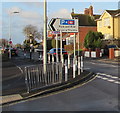
Direction signs at the northern end of Station Road, Rhoose
Pointing south, the larger sign shows Park and Ride and its Welsh equivalent.
The smaller sign shows a cycle route to Rhoose Cardiff International Airport railway station.
Image: © Jaggery
Taken: 11 Nov 2019
0.06 miles
8
Zebra crossing, Fontygary Road, Rhoose
Four stripe crossing near the Station Road junction ahead on the right.
Image: © Jaggery
Taken: 11 Nov 2019
0.07 miles
9
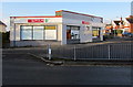
SPAR Rhoose
Station Road side of SPAR at 1 Fontygary Road in Rhoose.
Image: © Jaggery
Taken: 11 Nov 2019
0.07 miles
10
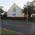
West side of St Peter's Church, Rhoose
Station Road side of the Church in Wales church on the corner of Church Road in the Diocese of Llandaff.
Image: © Jaggery
Taken: 11 Nov 2019
0.08 miles