IMAGES TAKEN NEAR TO
Romilly Road, BARRY, CF62 3AU
Introduction
This page details the photographs taken nearby to Romilly Road, CF62 3AU by members of the Geograph project.
The Geograph project started in 2005 with the aim of publishing, organising and preserving representative images for every square kilometre of Great Britain, Ireland and the Isle of Man.

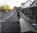
There are currently over 7.5m images from over14,400 individuals and you can help contribute to the project by visiting https://www.geograph.org.uk
Image Map
Images are licensed for reuse under creativecommons.org/licenses/by-sa/2.0
Notes
- Clicking on the map will re-center to the selected point.
- The higher the marker number, the further away the image location is from the centre of the postcode.
Image Listing (87 Images Found)
Images are licensed for reuse under creativecommons.org/licenses/by-sa/2.0
Image
Details
Distance
1
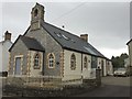
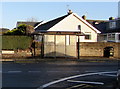
Jubilee Hall, Rhoose
Jubilee Hall, now Chapel House, Rhoose. Built in 1887 to commemorate Queen Victoria's 50th anniversary on the throne.
Image: © Alan Hughes
Taken: 10 Jan 2017
0.04 miles
2
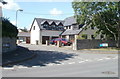
Jackson Close, Rhoose
A detached house occupies the corner of Jackson Close and Rhoose Road.
Image: © Jaggery
Taken: 11 Jun 2011
0.07 miles
3
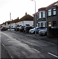
Houses on the south side of Church Road, Rhoose
Viewed from the corner of Station Road.
Image: © Jaggery
Taken: 11 Nov 2019
0.07 miles
4
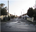
Church Road, Rhoose
East along Church Road from Station Road.
Image: © Jaggery
Taken: 11 Nov 2019
0.08 miles
5
Dark green cabinets, Rhoose Road, Rhoose
Two telecoms cabinets viewed from the corner of Station Road.
Image: © Jaggery
Taken: 11 Nov 2019
0.09 miles
6
Rhoose Road bus stop and shelter, Rhoose
This stop opposite Station Road is for buses to Barry.
Image: © Jaggery
Taken: 11 Nov 2019
0.09 miles
7
Jubilee Hall, Rhoose
Located on Rhoose Road. Jubilee Hall was built in 1887, the 50th year (golden jubilee) of Queen Victoria’s reign. It was originally a Gospel Mission. In 1938 it was bought by the Wesleyan Methodists. It became a dwelling after its use as a place of worship ended in the 1960s.
Image: © Jaggery
Taken: 11 Jun 2011
0.10 miles
8
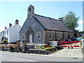
West side of St Peter's Church, Rhoose
Station Road side of the Church in Wales church on the corner of Church Road in the Diocese of Llandaff.
Image: © Jaggery
Taken: 11 Nov 2019
0.10 miles
9
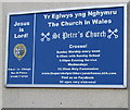
Information board on the west side of St Peter's Church, Rhoose
On the wall here https://www.geograph.org.uk/photo/6318861 viewed in November 2019. The church is in the Church in Wales Parish of Porthkerry & Rhoose in the Diocese of Llandaff.
Image: © Jaggery
Taken: 11 Nov 2019
0.10 miles
10
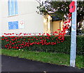
Poppies at the western edge of St Peter's Church, Rhoose
Located here https://www.geograph.org.uk/photo/6318861 alongside Station Road on Remembrance Day Monday November 11th 2019, the 100th anniversary of the first Remembrance Day on November 11th 1919. Nationwide a two minutes' silence is observed to remember the members of the armed forces who died in the line of duty. The tradition was begun by King George V in 1919, exactly a year after the Armistice on November 11th 1918 which marked the end of hostilities in the Great War (First World War). Hostilities formally ended at the 11th hour of the 11th day of the 11th month 1918. The First World War did not officially end until the signing of the Treaty of Versailles on 28 June 1919.
Image: © Jaggery
Taken: 11 Nov 2019
0.10 miles