IMAGES TAKEN NEAR TO
Morfa Lane, LLANTWIT MAJOR, CF61 2YT
Introduction
This page details the photographs taken nearby to Morfa Lane, CF61 2YT by members of the Geograph project.
The Geograph project started in 2005 with the aim of publishing, organising and preserving representative images for every square kilometre of Great Britain, Ireland and the Isle of Man.

There are currently over 7.5m images from over14,400 individuals and you can help contribute to the project by visiting https://www.geograph.org.uk
Image Map
Images are licensed for reuse under creativecommons.org/licenses/by-sa/2.0
Notes
- Clicking on the map will re-center to the selected point.
- The higher the marker number, the further away the image location is from the centre of the postcode.
Image Listing (2 Images Found)
Images are licensed for reuse under creativecommons.org/licenses/by-sa/2.0
Image
Details
Distance
1
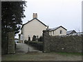
Morfa Farm
This must once have been the main entrance to the farm. There are some interestingly shaped capitals to the gateposts.
Image: © HelenK
Taken: 22 Feb 2008
0.08 miles
2
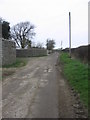
The road past Morfa Farm
Morfa Farm is protected by an unusually sturdy stone wall.
Image: © HelenK
Taken: 22 Feb 2008
0.11 miles