IMAGES TAKEN NEAR TO
Fairfield Rise, LLANTWIT MAJOR, CF61 2XT
Introduction
This page details the photographs taken nearby to Fairfield Rise, CF61 2XT by members of the Geograph project.
The Geograph project started in 2005 with the aim of publishing, organising and preserving representative images for every square kilometre of Great Britain, Ireland and the Isle of Man.

There are currently over 7.5m images from over14,400 individuals and you can help contribute to the project by visiting https://www.geograph.org.uk
Image Map
Images are licensed for reuse under creativecommons.org/licenses/by-sa/2.0
Notes
- Clicking on the map will re-center to the selected point.
- The higher the marker number, the further away the image location is from the centre of the postcode.
Image Listing (78 Images Found)
Images are licensed for reuse under creativecommons.org/licenses/by-sa/2.0
Image
Details
Distance
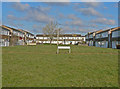
1
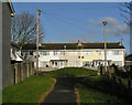
Vachell Court, Llantwit Major
One of several 'Courts' comprising this council estate.
Image: © Mick Lobb
Taken: 5 Jan 2009
0.06 miles
2
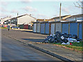
Refuse awaiting collection in Llantwit Major
The common sight of rubbish bags left for collection on our streets as we struggle to cope with our waste materials.
Image: © Mick Lobb
Taken: 5 Jan 2009
0.07 miles
3
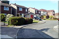
Nordale Road, Llantwit Major
Nordale Road is a short residential cul-de-sac on the north side of Boverton Road.
Image: © Jaggery
Taken: 9 Jul 2011
0.08 miles
4
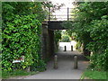
Pedestrian Underpass below Vale Line, Llantwit Major
Image: © Mick Lobb
Taken: 16 Jun 2008
0.08 miles
6
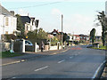
Boverton Road, Llantwit Major
At its junction with Ham Lane East. To the immediate right is the local rugby ground and, just past the junction, the sports fields attached to the local comprehensive school.
Image: © Mick Lobb
Taken: 5 Jan 2009
0.10 miles
7
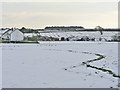
Across the school playing field in winter
The extensive playing fields belong to the local comprehensive school.
Image: © Mick Lobb
Taken: 3 Feb 2009
0.16 miles
8
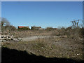
Station Yard - Llantwit Major
Dis-used for many a year there are plans for the site and two adjacent vacant properties to be developed to meet the growing need for housing.
Image: © Mick Lobb
Taken: 8 Mar 2010
0.17 miles
9

Station Yard - Llantwit Major
Dis-used for many a year the site has now been developed to meet the growing demand for housing. Image
Image: © Mick Lobb
Taken: 30 Apr 2015
0.17 miles
10
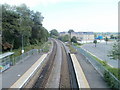
The view SE from Llantwit Major railway station footbridge
This view from the footbridge http://www.geograph.org.uk/photo/2499853 shows the 2-track Vale of Glamorgan line heading away from the station in the direction of Rhoose station. The road is Le Pouliguen Way, named after the French town twinned with Llantwit Major.
Image: © Jaggery
Taken: 9 Jul 2011
0.17 miles