IMAGES TAKEN NEAR TO
Caer Mead Close, LLANTWIT MAJOR, CF61 2UR
Introduction
This page details the photographs taken nearby to Caer Mead Close, CF61 2UR by members of the Geograph project.
The Geograph project started in 2005 with the aim of publishing, organising and preserving representative images for every square kilometre of Great Britain, Ireland and the Isle of Man.

There are currently over 7.5m images from over14,400 individuals and you can help contribute to the project by visiting https://www.geograph.org.uk
Image Map (103 Images)


Leaflet Map data © OpenStreetMap
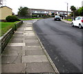
Images are licensed for reuse under creativecommons.org/licenses/by-sa/2.0
Notes
- Clicking on the map will re-center to the selected point.
- The higher the marker number, the further away the image location is from the centre of the postcode.
Image Listing (103 Images Found)
Images are licensed for reuse under creativecommons.org/licenses/by-sa/2.0
Image
Details
Distance
1
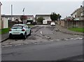
Unnamed side road in suburban Llantwit Major
On the west side of Eagleswell Road near De Clare Court. https://www.geograph.org.uk/photo/6278452
Image: © Jaggery
Taken: 25 Sep 2019
0.01 miles
2
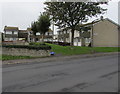
De Clare Court houses and trees, Llantwit Major
Set back from the west side of Eagleswell Road.
Image: © Jaggery
Taken: 25 Sep 2019
0.02 miles
3
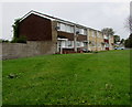
Row of houses on the west side of Eagleswell Road, Llantwit Major
Viewed from Bedford Rise.
Image: © Jaggery
Taken: 25 Sep 2019
0.04 miles
4
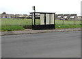
Eagleswell Road bus stop and shelter, Llantwit Major
In September 2019 this is a stop on two bus routes - route 303 to Barry and route 321 to Talbot Green via Cowbridge. The railings are at the edge of a derelict site formerly occupied by a school.
Image: © Jaggery
Taken: 25 Sep 2019
0.05 miles
5
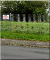
KEEP OUT notice on railings, Eagleswell Road, Llantwit Major
Viewed in September 2019. The Cuddy Group notice is on perimeter railings at the southwest edge of the site formerly occupied by Eagleswell Primary & Nursery School. Satellite views show that the school buildings have been demolished.
Image: © Jaggery
Taken: 25 Sep 2019
0.05 miles
6
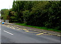
Traffic calming on Eagleswell Road, Llantwit Major
The sign shows that vehicles on the camera side have priority ahead.
Image: © Jaggery
Taken: 25 Sep 2019
0.06 miles
7
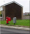
Two Royal Mail drop boxes, Bedford Rise, Llantwit Major
A grey drop box is alongside a smaller red drop box attached to a pillarbox.
I cannot recall seeing two Royal Mail drop boxes together before.
Image: © Jaggery
Taken: 25 Sep 2019
0.06 miles
8
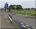
Zigzag yellow markings on Eagleswell Road, Llantwit Major
Marking a School Keep Clear Zone, the yellow markings remain in September 2019, several years after Eagleswell Primary & Nursery School closed down. Satellite views show that the school buildings have been demolished.
Image: © Jaggery
Taken: 25 Sep 2019
0.06 miles
9
Bend in Bedford Rise, Llantwit Major
Viewed from the corner of Eagleswell Road. The corner of Grey's Drive is ahead on the left.
Image: © Jaggery
Taken: 25 Sep 2019
0.06 miles
10
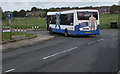
Blue & white bus on a Llantwit Major corner
Turning from Bedford Rise into Eagleswell Road in September 2019, the NAT Group bus is on bus route 321 to Llantwit Major bus station from Talbot Green via Cowbridge.
Image: © Jaggery
Taken: 25 Sep 2019
0.06 miles