1
Windmill Lane houses, Llantwit Major
This part of Windmill Lane is north of the Windmill Close junction.
Image: © Jaggery
Taken: 25 Sep 2019
0.01 miles
2
Rooftop solar panels, Windmill Lane, Llantwit Major
On a roof facing southwest.
Image: © Jaggery
Taken: 25 Sep 2019
0.01 miles
3
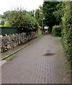
Windmill Lane between a stone wall and hedges, Llantwit Major
Ahead for the former Frampton Windmill. https://www.geograph.org.uk/photo/3176429
Image: © Jaggery
Taken: 25 Sep 2019
0.03 miles
4
Houses on the east side of Windmill Lane, Llantwit Major
Semi-detached houses viewed from the corner of Windmill Close.
Image: © Jaggery
Taken: 25 Sep 2019
0.03 miles
5
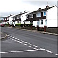
West side of Windmill Lane, Llantwit Major
The broken white lines on the left are at the Windmill Close junction. https://www.geograph.org.uk/photo/6277531
Image: © Jaggery
Taken: 25 Sep 2019
0.03 miles
6
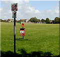
Signs at a Windmill Lane entrance to a recreation area, Llantwit Major
The signs all have a diagonal red line through them, indicating that the activity shown is not allowed. Three of the signs are No horse riding, no cycling and no camping. The sign at top left was unclear to me - perhaps indicating no golf practice. A separate notice underneath indicates that this is a designated public place where no alcohol is to be consumed.
Image: © Jaggery
Taken: 9 Jul 2011
0.03 miles
7
Up Windmill Lane, Llantwit Major
Windmill Lane ascends away from the Llanmaes Road junction.
The Windmill Close junction https://www.geograph.org.uk/photo/6277531 is ahead on the left.
Image: © Jaggery
Taken: 25 Sep 2019
0.05 miles
8
Windmill Close, Llantwit Major
Viewed from Windmill Lane.
Image: © Jaggery
Taken: 9 Jul 2011
0.05 miles
9
Windmill Close in Llantwit Major
Cul-de-sac on the west side of Windmill Lane.
Image: © Jaggery
Taken: 25 Sep 2019
0.06 miles
10
Detached houses, Llanmaes Road, Llantwit Major
Viewed across the yellow Keep Clear Zone near the town's fire station and ambulance station.
Image: © Jaggery
Taken: 25 Sep 2019
0.06 miles


