IMAGES TAKEN NEAR TO
Gildas Close, LLANTWIT MAJOR, CF61 2SL
Introduction
This page details the photographs taken nearby to Gildas Close, CF61 2SL by members of the Geograph project.
The Geograph project started in 2005 with the aim of publishing, organising and preserving representative images for every square kilometre of Great Britain, Ireland and the Isle of Man.

There are currently over 7.5m images from over14,400 individuals and you can help contribute to the project by visiting https://www.geograph.org.uk
Image Map
Images are licensed for reuse under creativecommons.org/licenses/by-sa/2.0
Notes
- Clicking on the map will re-center to the selected point.
- The higher the marker number, the further away the image location is from the centre of the postcode.
Image Listing (136 Images Found)
Images are licensed for reuse under creativecommons.org/licenses/by-sa/2.0
Image
Details
Distance
1
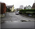
Great House Meadows, Llantwit Major
Cul-de-sac on the east side of High Street. The Great House http://www.geograph.org.uk/photo/4417826 is nearby.
Image: © Jaggery
Taken: 3 Apr 2015
0.07 miles
2
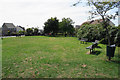
A seating area on amenity land
Part of housing expansion to the north of Llantwit Major. It all seems in remarkably good condition.
Image: © Bill Boaden
Taken: 4 Aug 2018
0.09 miles
4
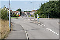
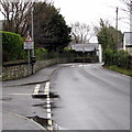
Roundabout on Heol Pentre'r Cwrt
Recent housing expansion on the north side of Llantwit Major. The only vehicular access is from the road to the right.
Image: © Bill Boaden
Taken: 4 Aug 2018
0.11 miles
5
Single file traffic sign, High Street, Llantwit Major
Near the corner of Great House Meadows. http://www.geograph.org.uk/photo/4417850
Image: © Jaggery
Taken: 3 Apr 2015
0.11 miles
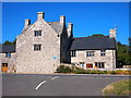
6
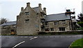
The Great House, Llantwit Major
The Great House (Tŷ Mawr in Welsh) is on the east side of High Street, facing Castle Street. The blue plaque http://www.geograph.org.uk/photo/4417831 on the building states that this a late 15th century house which incorporates many defensive features. A southern wing was added in the 17th century. It was associated with the Nicholl family, the most prominent of the local landed gentry. The family produced many distinguished representatives in the fields of medicine, art, law and the church.
Image: © Jaggery
Taken: 3 Apr 2015
0.11 miles
7
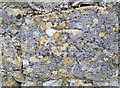
Ordnance Survey Cut Mark
This OS cut mark can be found on the Great House. It marks a point 51.645m above mean sea level.
Image: © Adrian Dust
Taken: 11 Mar 2018
0.11 miles
8
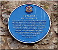
The Great House (Tŷ Mawr) blue plaque, Llantwit Major
On the wall here. http://www.geograph.org.uk/photo/4417826
Image: © Jaggery
Taken: 3 Apr 2015
0.11 miles
9
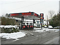
'Jenks' Garage, Llantwit Major
Hard to say how long this garage will remain as so many have gone out of business in recent years. I understand that planning permission has been requested for the building of houses on the site so it probably won't be long.
Image: © Mick Lobb
Taken: 3 Feb 2009
0.12 miles
10
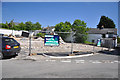
.... and so it came to pass!
One hopes that any building will be in keeping with its surroundings in this old part of town. Image
Image: © Mick Lobb
Taken: 23 Jun 2010
0.12 miles