1
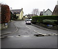
A seating area on amenity land
Part of housing expansion to the north of Llantwit Major. It all seems in remarkably good condition.
Image: © Bill Boaden
Taken: 4 Aug 2018
0.05 miles
2
Roundabout on Heol Pentre'r Cwrt
Recent housing expansion on the north side of Llantwit Major. The only vehicular access is from the road to the right.
Image: © Bill Boaden
Taken: 4 Aug 2018
0.07 miles
3
Pedestrian access, West end of Llantwit Major
The footpath offers a shortcut for pedestrians to this small housing development.
Image: © Mick Lobb
Taken: 3 Feb 2009
0.10 miles
4
Llys Dewi, Llantwit Major
Cul-de-sac viewed from Groeswen.
Image: © Jaggery
Taken: 3 Apr 2015
0.11 miles
5
Great House Meadows, Llantwit Major
Cul-de-sac on the east side of High Street. The Great House http://www.geograph.org.uk/photo/4417826 is nearby.
Image: © Jaggery
Taken: 3 Apr 2015
0.11 miles
6
Ty Mawr, Llanilltud Fawr
Image: © Chris Andrews
Taken: 27 Jun 2018
0.12 miles
7
Ordnance Survey Cut Mark
This OS cut mark can be found on the Great House. It marks a point 51.645m above mean sea level.
Image: © Adrian Dust
Taken: 11 Mar 2018
0.12 miles
8
The Great House, Llantwit Major
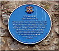
The Great House (Tŷ Mawr in Welsh) is on the east side of High Street, facing Castle Street. The blue plaque http://www.geograph.org.uk/photo/4417831 on the building states that this a late 15th century house which incorporates many defensive features. A southern wing was added in the 17th century. It was associated with the Nicholl family, the most prominent of the local landed gentry. The family produced many distinguished representatives in the fields of medicine, art, law and the church.
Image: © Jaggery
Taken: 3 Apr 2015
0.13 miles
9
High Street, Llantwit Major
Still heading towards the town centre. The road is characterised by narrow sections where drivers can practise courtesy, and speed bumps.
Image: © Bill Boaden
Taken: 4 Aug 2018
0.13 miles
10
The Great House (Tŷ Mawr) blue plaque, Llantwit Major
On the wall here. http://www.geograph.org.uk/photo/4417826
Image: © Jaggery
Taken: 3 Apr 2015
0.13 miles


