IMAGES TAKEN NEAR TO
Gwaun Illtuds, LLANTWIT MAJOR, CF61 2SE
Introduction
This page details the photographs taken nearby to Gwaun Illtuds, CF61 2SE by members of the Geograph project.
The Geograph project started in 2005 with the aim of publishing, organising and preserving representative images for every square kilometre of Great Britain, Ireland and the Isle of Man.

There are currently over 7.5m images from over14,400 individuals and you can help contribute to the project by visiting https://www.geograph.org.uk
Image Map
Images are licensed for reuse under creativecommons.org/licenses/by-sa/2.0
Notes
- Clicking on the map will re-center to the selected point.
- The higher the marker number, the further away the image location is from the centre of the postcode.
Image Listing (79 Images Found)
Images are licensed for reuse under creativecommons.org/licenses/by-sa/2.0
Image
Details
Distance
1
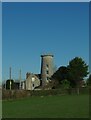
Bryn Illtud Mill, Llantwit Major
This mill was built some time around 1820 with 4 sails and a stage. Its working life was quite short lived as A.T.Evans was the last active miller in 1846.
Around 1980 the then owner had ideas of 'restoring' the mill to look how it would have looked originally but to use it to generate electricity rather than milling flour. His plans never came to fruition and it is now part of a domestic residence.
Image: © Colin Cheesman
Taken: 14 Jan 2022
0.02 miles
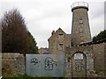
2
Former Frampton Windmill, Llantwit Major
Viewed from Windmill Lane.
The windmill was built c1820 as a 3 storey conical tower.
Its working life was only about 25 years : it ceased working c1846.
The tower was raised a further two storeys when the mill
and adjacent barn were converted to a dwelling in the early 1980s.
Image: © Jaggery
Taken: 9 Jul 2011
0.03 miles
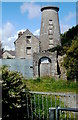
3
Old Windmill, Llantwit Major
This forlorn old mill is a prominent local landmark.
Image: © Stephen McKay
Taken: 15 Dec 2006
0.03 miles
4
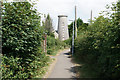
Footpath past the windmill
The windmill is Grade II listed but is currently in a derelict state.
Image: © Bill Boaden
Taken: 4 Aug 2018
0.05 miles
5
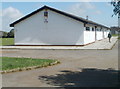
Sports pavilion near Windmill Lane, Llantwit Major
The 50 metre long pavilion is on the western side of a recreation ground.
Image: © Jaggery
Taken: 9 Jul 2011
0.09 miles
6
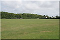
Windmill Lane Playing Fields
A well-maintained large expanse of grass.
Image: © Bill Boaden
Taken: 4 Aug 2018
0.09 miles
7
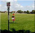
Signs at a Windmill Lane entrance to a recreation area, Llantwit Major
The signs all have a diagonal red line through them, indicating that the activity shown is not allowed. Three of the signs are No horse riding, no cycling and no camping. The sign at top left was unclear to me - perhaps indicating no golf practice. A separate notice underneath indicates that this is a designated public place where no alcohol is to be consumed.
Image: © Jaggery
Taken: 9 Jul 2011
0.11 miles
8
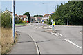
Roundabout on Heol Pentre'r Cwrt
Recent housing expansion on the north side of Llantwit Major. The only vehicular access is from the road to the right.
Image: © Bill Boaden
Taken: 4 Aug 2018
0.11 miles
10
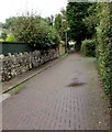
Windmill Lane between a stone wall and hedges, Llantwit Major
Ahead for the former Frampton Windmill. https://www.geograph.org.uk/photo/3176429
Image: © Jaggery
Taken: 25 Sep 2019
0.11 miles